#geospatialanalysis search results

Crop Type Classification with Machine Learning & Ground Truth Data Tutorial Link: youtube.com/live/S9no403GT… For more information about registration, visit our website: studyhacksgeospatial.com/google-earth-e… #MachineLearning #GeospatialAnalysis #RemoteSensing #GoogleEarthEngine #GIS

1/3 we used #GIS and #RemoteSensing to map landslide-prone areas in Kapchorwa District, Uganda (1980–2018). Our goal: to identify terrain-based susceptibility zones and support disaster risk reduction in the Mount Elgon region. More: #GeospatialAnalysis #QGIS #Uganda


Join me on a journey into the fascinating world of #GeospatialAnalysis using #QGIS! Discover advanced techniques, real-world applications, and the power of open-source GIS. Let's map our future together! #YouthMappers #GIS @YMsummitUganda @youthmappers


Anabranch is proud to support development of the open source QGIS platform, an essential part of our geospatial analysis and cartographic toolkit. The price ain’t bad either! #GIS #geospatialanalysis


📣 Highlights from an Interesting Paper 📣 Is Zagreb Green Enough? Influence of Urban Green Spaces on Mitigation of Urban Heat Island: A Satellite-Based Study 🧑⚖️ By Goran Krsnik 📖 Read the full study: mdpi.com/2673-4834/5/4/… #urbanclimate #geospatialanalysis #thermalgraphs


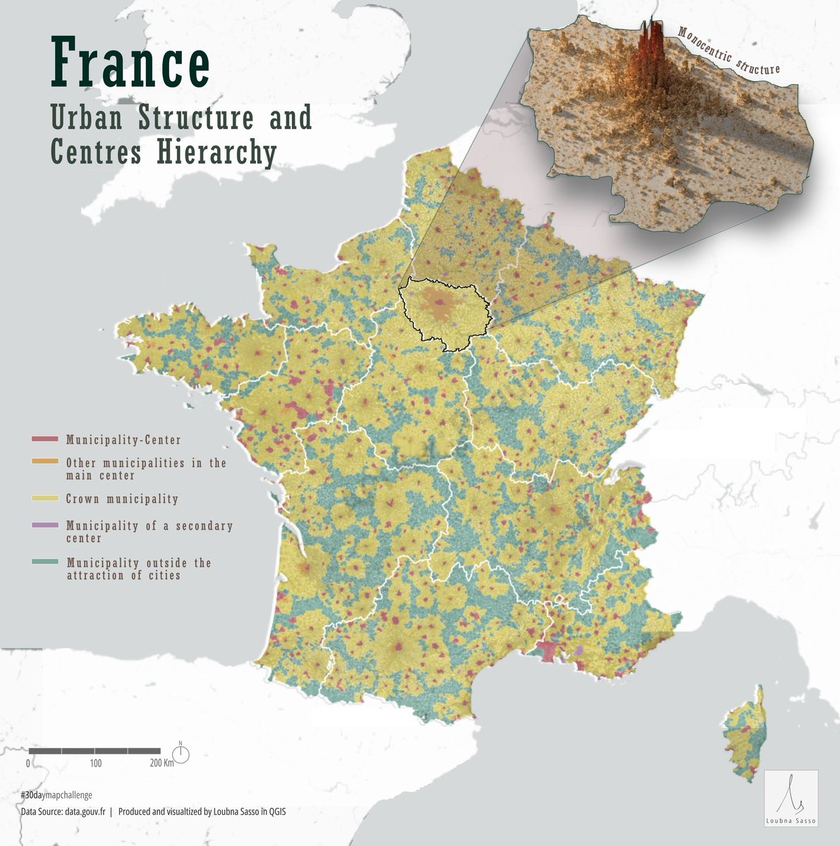
Day 13 of #30daymapchallenge - Europe Visualizing the urban structure of France, including the hierarchy of centres across different cities and a detailed visualization of Paris's monocentric urban form #geospatialanalysis #dataanalysis #GIS #urbanplanning #urbandesign
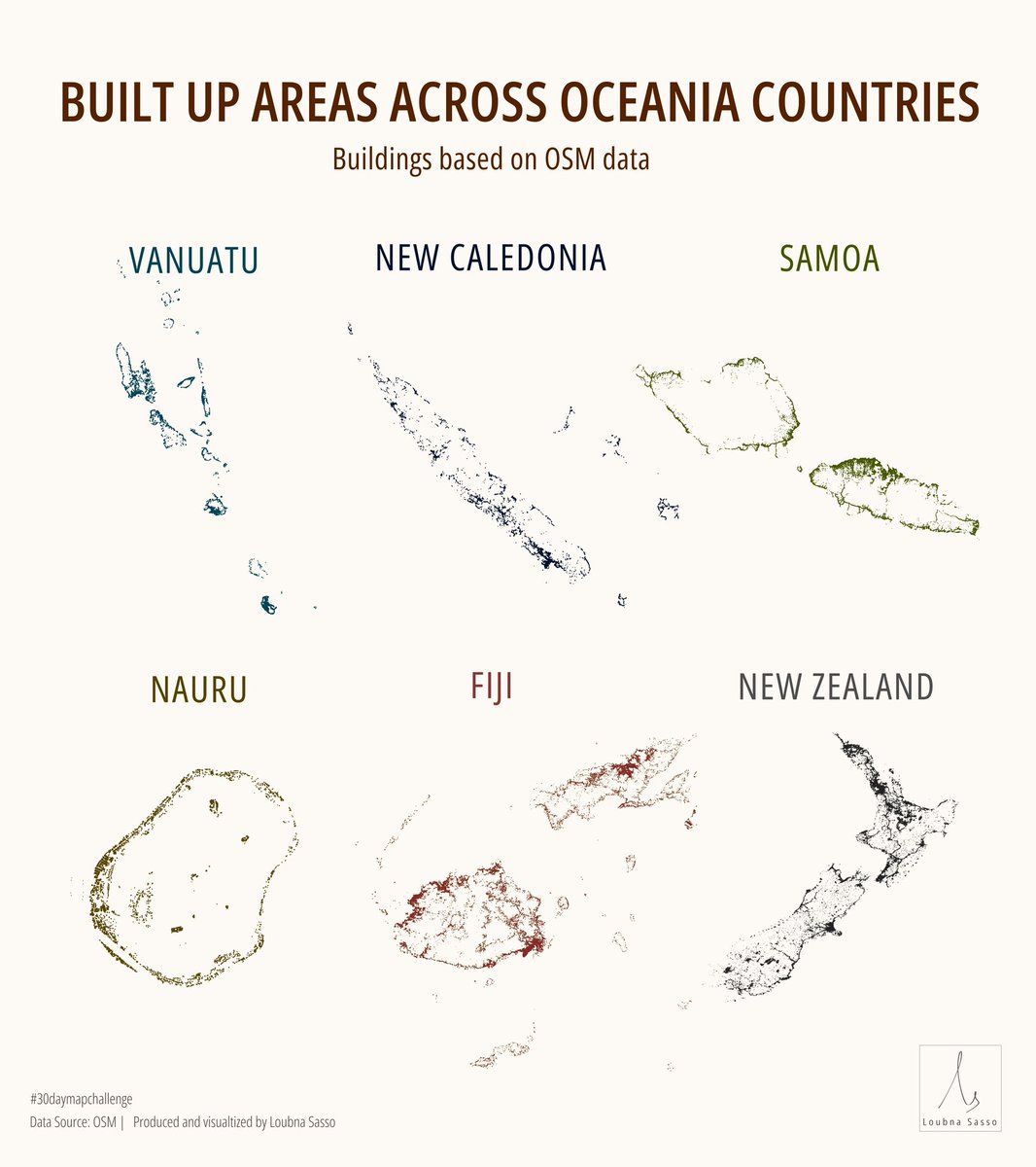
Day 15 of #30daymapchallenge - OSM! A simple visualizing of built up areas across various countries in Oceania #cartography #geospatialanalysis #dataanalysis #GIS #urbanplanning #urbandesign
If you're using QGIS for project design and haven't tried Qfield for days gathering data in the field, we highly recommend! Super helpful for post and pre-restoration habitat surveys as well. #QGIS #Qfield #geospatialanalysis #conservation #restoration


🌐 Geospatial Analytics | KNIME: My Journey from Montoro to Barbate 🏖 🗺 Map out areas of interest 🍤 Discover hidden gems (restaurants, beaches, etc.) 🛣 Visualize the perfect road trip route 📌linkedin.com/pulse/geospati… #KNIME #DataScience #GeospatialAnalysis #Geopandas

We're revolutionizing #GeospatialAnalysis with GIQ, our cutting-edge AI-based platform designed to transform how you explore, analyze, and visualize spatial data. #Space42 #GITEX2024

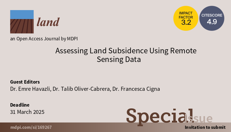
🚨 Call for Papers! 🚨 Our special issue, "Assessing Land Subsidence Using Remote Sensing Data," in @Land_MDPI, has an extended submission deadline of March 31, 2025. Submit your research on #RemoteSensing, #LandSubsidence, and #GeospatialAnalysis. 🌍📊 #EarthObservation

🌍Today, on the Day Against #IUUFishing, SatCen is proud to contribute to the combatting of illegal fishing activities by supporting @EFCA_EU ! #Geospatialanalysis is an important tool to ensure responsible fishing practices that safeguard our oceans for future generations.🐋

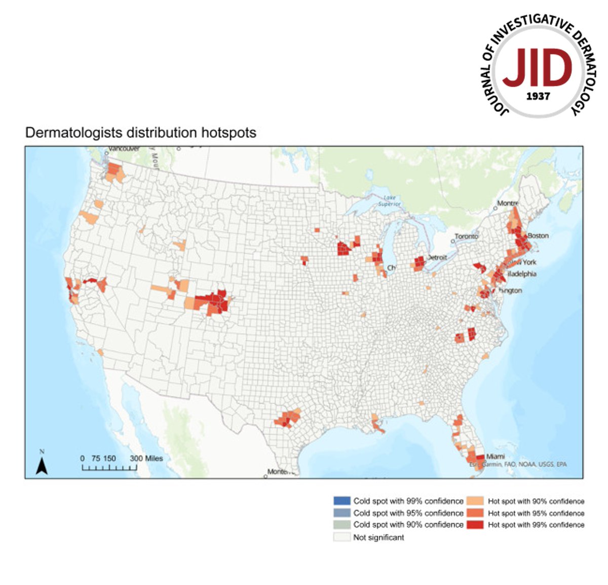
Read the April issue Methods and Techniques for Skin Research Article from Tran et al: Applications and Best Practices for #geospatialanalysis Research in #dermatology doi.org/10.1016/j.jid.… #dermtwitter #dermatology #dermresearch
Another remarkable day at @GITEX_GLOBAL 2024! We welcomed VIP visitors and stakeholders to our stand, including Peng Xiao, Group CEO of @G42ai, to learn about #Space42's product offerings, such as our innovative #GIQ platform to revolutionize #GeospatialAnalysis.

Graduate students in Dr. Ekici’s INTL 595 Geospatial Intelligence course are utilizing ArcGIS to develop advanced skills in mapping and analyzing large datasets! #HURSTisHOME #GeospatialAnalysis #intelligence


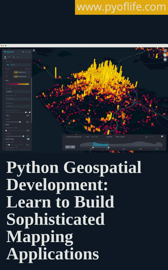
If you’re a beginner Python developer, GIS professional, data scientist, or urban planner, mastering Python’s geospatial capabilities can significantly enhance your toolkit. pyoflife.com/interactive-ma… #DataScience #pythonprogramming #geospatialanalysis #DataScientists #dataviz

Going beyond 'location, location, location' w/ Helen McKenzie (@helenmakesmaps), #GeospatialAdvocate. 📺 / 📻: link.chtbl.com/steampowered 🌐: steampoweredshow.com/shows/helen-mc… #DataScience #GeospatialAnalysis #UrbanPlanning #UrbanDevelopment

Alteryx #LocationIntelligence enables everyone to make intelligent, scalable location-based decisions and conduct #GeospatialAnalysis using a unified, map-based, enterprise-grade solution for creating geospatial-based insights. 🎥 Watch our overview: ow.ly/167350Q8AhZ

We chat w/ Helen McKenzie (@helenmakesmaps) about geospatial analysis and making information beautiful. 📺 / 📻: link.chtbl.com/steampowered 🌐: steampoweredshow.com/shows/helen-mc… #GeospatialAnalysis #GIS #DataScience #maps


Interactive WebGIS map to visualize seismic activity along the Red Sea-Afar-East African Rift System (RSEARS). This region marks one of the most geologically active continental rift zones on Earth. #GIS #Geology #GeospatialAnalysis #DataVisualization


Understanding both helps researchers, urban planners, and data scientists make informed, location-based decisions. 💡 Stay tuned as we break down more key spatial analysis concepts! #SpatialData #GeospatialAnalysis #DataScience #SpatialAutocorrelation #GIS #SDSSN

Rising Heat in Expanding Cities: The Cuttack–Bhubaneswar Story Read here: dx.doi.org/10.12944/CWE.2… #UrbanHeatIsland #GeospatialAnalysis #SustainableCities #EnvironmentalResearch #UrbanEcology #RemoteSensing #ClimateChange #Bhubaneswar #Cuttack #LandUseChange #ResearchHighlight

1/3 we used #GIS and #RemoteSensing to map landslide-prone areas in Kapchorwa District, Uganda (1980–2018). Our goal: to identify terrain-based susceptibility zones and support disaster risk reduction in the Mount Elgon region. More: #GeospatialAnalysis #QGIS #Uganda

Trying out geospatial analysis and all I can say is omoooo When I am done I will share my work for corrections and addition #dataanalysis #geospatialanalysis #showingup
Tutorial Link: 34th Batch Master Remote Sensing with Google Earth Engine (Beginner to Advanced) The link: youtube.com/live/lGfSSKZ2n… #RemoteSensing #GoogleEarthEngine #GeospatialAnalysis #GIS #DataScience #EarthObservation #SatelliteImagery #EnvironmentalMonitoring


Walmart is a standout example. The global retailer uses GIS to optimize store placement, delivery routes, and logistics, dividing territories into data grids that track customer density, drive times, and sales potential. #SmartLogistics #GeospatialAnalysis


Crop Type Classification with Machine Learning & Ground Truth Data Tutorial Link: youtube.com/live/S9no403GT… For more information about registration, visit our website: studyhacksgeospatial.com/google-earth-e… #MachineLearning #GeospatialAnalysis #RemoteSensing #GoogleEarthEngine #GIS

(Open Access) Geospatial Analysis with Python: freecomputerbooks.com/Geospatial-Ana… Look for "Read and Download Links" section to download. Follow me if you like this post. #GIS #GeospatialAnalysis #Python #programming #SpatialAnalysis #SpatialData #GeospatialData
📣 Highlights from an Interesting Paper 📣 Is Zagreb Green Enough? Influence of Urban Green Spaces on Mitigation of Urban Heat Island: A Satellite-Based Study 🧑⚖️ By Goran Krsnik 📖 Read the full study: mdpi.com/2673-4834/5/4/… #urbanclimate #geospatialanalysis #thermalgraphs
Tutorial Link: 34th Batch Master Remote Sensing with Google Earth Engine (Beginner to Advanced) The link: youtube.com/live/lGfSSKZ2n… #RemoteSensing #GoogleEarthEngine #GeospatialAnalysis #GIS #DataScience #EarthObservation #SatelliteImagery #EnvironmentalMonitoring

🌍 Just completed the Fundamentals of Remote Sensing Level 1 course by the Mahmoud Othman Center! Excited to apply these skills! 🚀 #RemoteSensing #GIS #GeospatialAnalysis

🚨 Call for Papers! 🚨 Our special issue, "Assessing Land Subsidence Using Remote Sensing Data," in @Land_MDPI, has an extended submission deadline of March 31, 2025. Submit your research on #RemoteSensing, #LandSubsidence, and #GeospatialAnalysis. 🌍📊 #EarthObservation

80% of data whispers location secrets! DeepSpatial unlocks the power of geospatial AI, transforming whispers into impactful decisions for a future shaped by location. #ai #geospatial #geospatialanalysis #datadriven #futuretech #innovation #GeoAIFuture $DSAI $DSAIF $DSAI.CN

Anabranch is proud to support development of the open source QGIS platform, an essential part of our geospatial analysis and cartographic toolkit. The price ain’t bad either! #GIS #geospatialanalysis
Stay Ahead of the Competition! Gain the insights you need to outpace your competitors and drive growth. Our data-driven insights and strategic analysis empower you to make the best decisions for your business. #ai #geospatial #geospatialanalysis #datadriven $DSAI $DSAIF $DSAI.CN


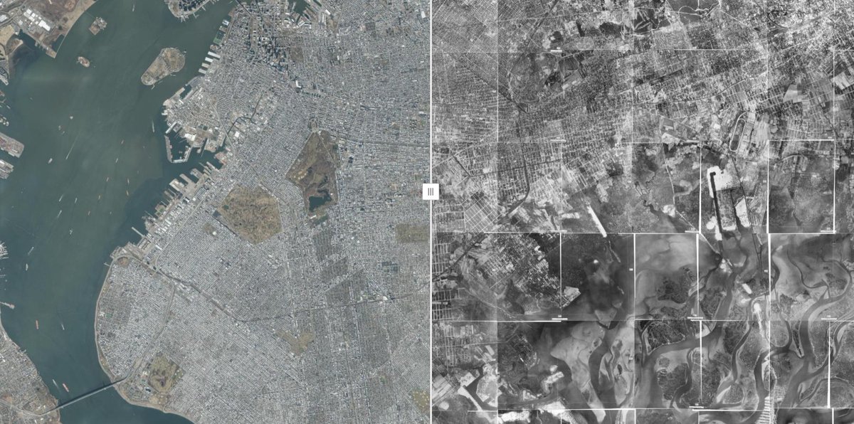
🚀 TOP 25 Coolest GIS Visualization Tools! 🌍 ✨Number 1: NYC Then & Now 👉 #GIS #DataVisualization #GeospatialAnalysis #MappingTools nyc.maps.arcgis.com/apps/instant/m…

Building useful #tourismdata for your travel app? Xtract.io provides POI data for over 400 malls across the European Union. The dataset helps improve user experience by enhancing location discovery and recommendations. #geospatialanalysis zurl.co/aOBnq

Read the April issue Methods and Techniques for Skin Research Article from Tran et al: Applications and Best Practices for #geospatialanalysis Research in #dermatology doi.org/10.1016/j.jid.… #dermtwitter #dermatology #dermresearch
Join me on a journey into the fascinating world of #GeospatialAnalysis using #QGIS! Discover advanced techniques, real-world applications, and the power of open-source GIS. Let's map our future together! #YouthMappers #GIS @YMsummitUganda @youthmappers

Assistant Professor of Geospatial Analysis owlindex.com/service-explor… #Owlindex #GeospatialAnalysis #VCU #EnvironmentalStudies #HigherEd #AcademicJobs #FacultyPosition #DataScience #GIS #Sustainability #ResearchOpportunity

(Legally FREE) Geospatial Analysis: A Comprehensive Guide to Principles, Techniques and Software Tools - freecomputerbooks.com/Geospatial-Ana… Look for "Read and Download Links" section to download. Follow me if you like this. #GeospatialAnalysis #GIS #SpatialAnalysis #SpatialData #ArcGIS,

Geospatial Analysis: A Comprehensive Guide to Principles, Techniques and Software Tools - lnkd.in/eixapGme Look for "Read and Download Links" section to download. Follow me if you like this. #GeospatialAnalysis #GeospatialData #GIS #SpatialAnalysis #SpatialData #statistics


Turn raw data into insights with ERDAS APOLLO: • Automate workflows • Deploy models easily • Extract actionable insights Watch the webinar to learn more: bit.ly/4bWy0qL #ERDASAPOLLO #GeospatialAnalysis

Day 15 of #30daymapchallenge - OSM! A simple visualizing of built up areas across various countries in Oceania #cartography #geospatialanalysis #dataanalysis #GIS #urbanplanning #urbandesign

#AI #AIArchaeology #GeospatialAnalysis #DataClustering Twitter, Facebook and Instagram. A bone and shell bead discovered at Heaning Wood Bone Cave by local archaeologist Martin Stables and analysed by the University of Central Lancashire have led to the discovery of some of the…

Something went wrong.
Something went wrong.
United States Trends
- 1. Steelers 49K posts
- 2. Rodgers 20.2K posts
- 3. Chargers 32.3K posts
- 4. Tomlin 7,579 posts
- 5. Schumer 204K posts
- 6. #HereWeGo 5,464 posts
- 7. #BoltUp 2,595 posts
- 8. Keenan Allen 3,996 posts
- 9. Herbert 10.9K posts
- 10. Resign 96.3K posts
- 11. Tim Kaine 14.9K posts
- 12. #RHOP 6,546 posts
- 13. Durbin 21.6K posts
- 14. Ladd 4,172 posts
- 15. #ITWelcomeToDerry 3,870 posts
- 16. Jaylen Warren 1,845 posts
- 17. Cornyn 13.2K posts
- 18. #snfonnbc N/A
- 19. Angus King 12.5K posts
- 20. Arthur Smith N/A