#geospatialanalysis 搜尋結果

Crop Type Classification with Machine Learning & Ground Truth Data Tutorial Link: youtube.com/live/S9no403GT… For more information about registration, visit our website: studyhacksgeospatial.com/google-earth-e… #MachineLearning #GeospatialAnalysis #RemoteSensing #GoogleEarthEngine #GIS


Another remarkable day at @GITEX_GLOBAL 2024! We welcomed VIP visitors and stakeholders to our stand, including Peng Xiao, Group CEO of @G42ai, to learn about #Space42's product offerings, such as our innovative #GIQ platform to revolutionize #GeospatialAnalysis.

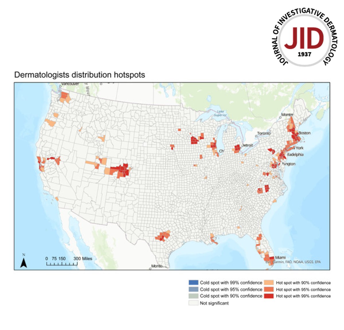
Read the April issue Methods and Techniques for Skin Research Article from Tran et al: Applications and Best Practices for #geospatialanalysis Research in #dermatology doi.org/10.1016/j.jid.… #dermtwitter #dermatology #dermresearch

Join me on a journey into the fascinating world of #GeospatialAnalysis using #QGIS! Discover advanced techniques, real-world applications, and the power of open-source GIS. Let's map our future together! #YouthMappers #GIS @YMsummitUganda @youthmappers


Join Wendy Guan (@Harvard Center for Geographic Analysis), @CadiliD (@knime) & me for tonight's webinar "Geospatial Analytics Made Easy with KNIME". Learn about #geospatialanalysis & how to do it with #KNIME💡 Don't miss out - register here ➡ hopin.com/events/geospat… #learning
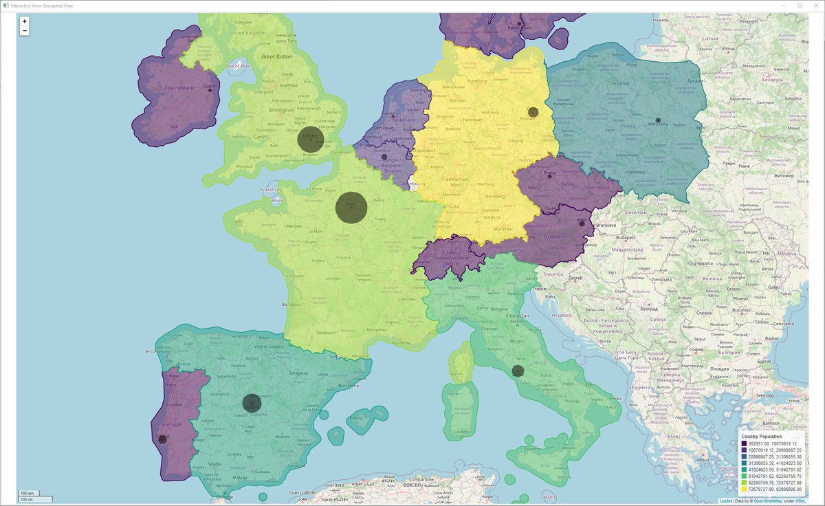

Did you know that #geospatial analysis is possible with @knime? Read how @HarvardCGA have developed a #lowcode solution to make #geospatialanalysis available to all. Learn more in the article: eu1.hubs.ly/H02QkqC0 #Harvard #KNIME #datascience

Anabranch is proud to support development of the open source QGIS platform, an essential part of our geospatial analysis and cartographic toolkit. The price ain’t bad either! #GIS #geospatialanalysis


If you're using QGIS for project design and haven't tried Qfield for days gathering data in the field, we highly recommend! Super helpful for post and pre-restoration habitat surveys as well. #QGIS #Qfield #geospatialanalysis #conservation #restoration


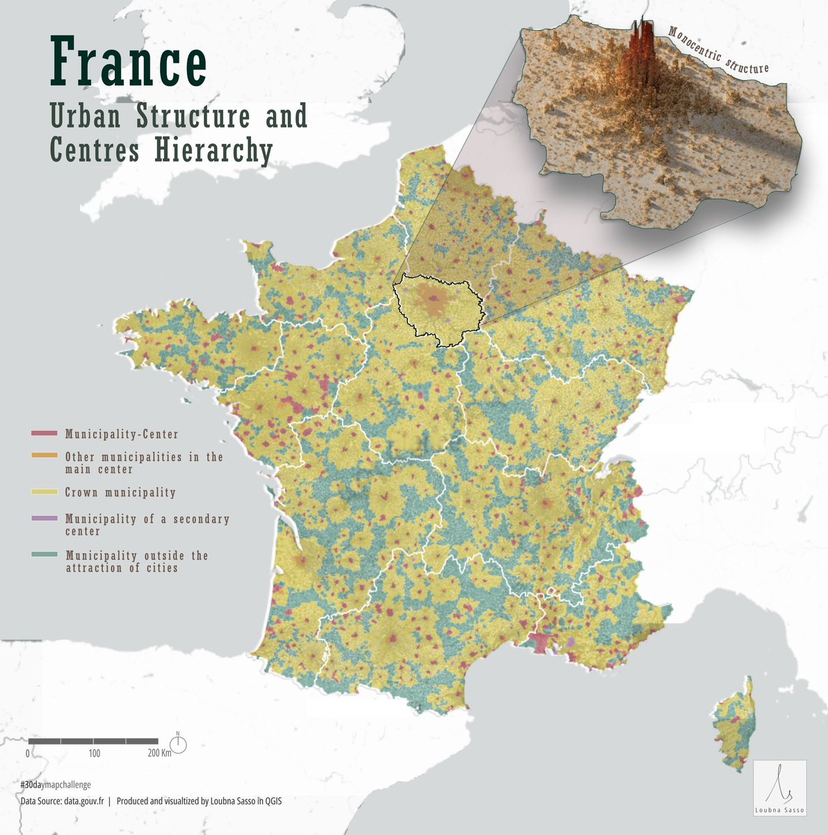
Day 13 of #30daymapchallenge - Europe Visualizing the urban structure of France, including the hierarchy of centres across different cities and a detailed visualization of Paris's monocentric urban form #geospatialanalysis #dataanalysis #GIS #urbanplanning #urbandesign
We're revolutionizing #GeospatialAnalysis with GIQ, our cutting-edge AI-based platform designed to transform how you explore, analyze, and visualize spatial data. #Space42 #GITEX2024
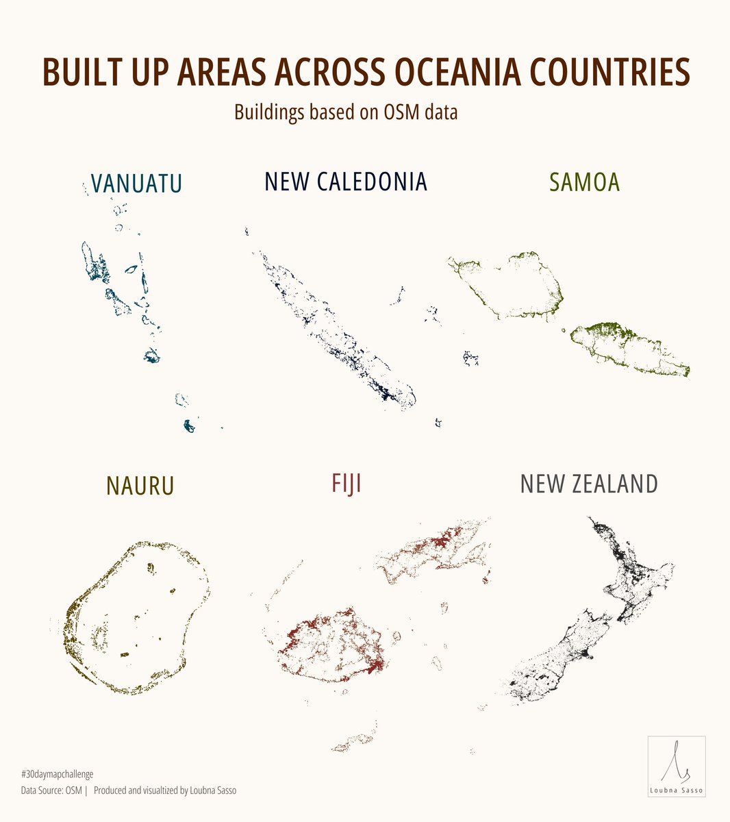
Day 15 of #30daymapchallenge - OSM! A simple visualizing of built up areas across various countries in Oceania #cartography #geospatialanalysis #dataanalysis #GIS #urbanplanning #urbandesign

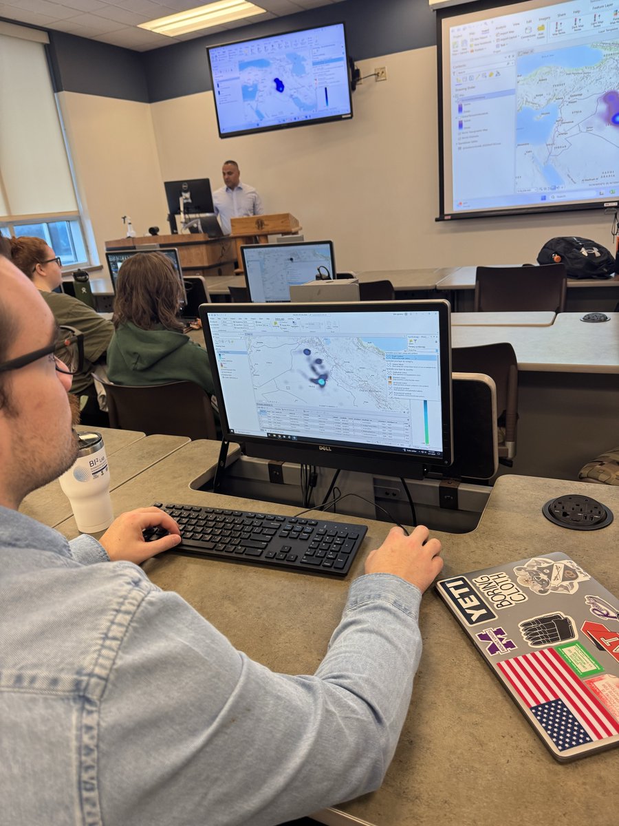
Graduate students in Dr. Ekici’s INTL 595 Geospatial Intelligence course are utilizing ArcGIS to develop advanced skills in mapping and analyzing large datasets! #HURSTisHOME #GeospatialAnalysis #intelligence


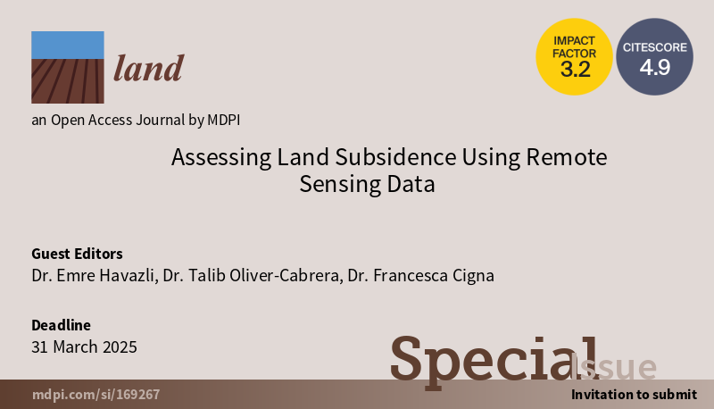
🚨 Call for Papers! 🚨 Our special issue, "Assessing Land Subsidence Using Remote Sensing Data," in @Land_MDPI, has an extended submission deadline of March 31, 2025. Submit your research on #RemoteSensing, #LandSubsidence, and #GeospatialAnalysis. 🌍📊 #EarthObservation

🌐 Geospatial Analytics | KNIME: My Journey from Montoro to Barbate 🏖 🗺 Map out areas of interest 🍤 Discover hidden gems (restaurants, beaches, etc.) 🛣 Visualize the perfect road trip route 📌linkedin.com/pulse/geospati… #KNIME #DataScience #GeospatialAnalysis #Geopandas

🌍Today, on the Day Against #IUUFishing, SatCen is proud to contribute to the combatting of illegal fishing activities by supporting @EFCA_EU ! #Geospatialanalysis is an important tool to ensure responsible fishing practices that safeguard our oceans for future generations.🐋

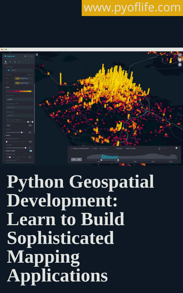
If you’re a beginner Python developer, GIS professional, data scientist, or urban planner, mastering Python’s geospatial capabilities can significantly enhance your toolkit. pyoflife.com/interactive-ma… #DataScience #pythonprogramming #geospatialanalysis #DataScientists #dataviz

📣 Highlights from an Interesting Paper 📣 Is Zagreb Green Enough? Influence of Urban Green Spaces on Mitigation of Urban Heat Island: A Satellite-Based Study 🧑⚖️ By Goran Krsnik 📖 Read the full study: mdpi.com/2673-4834/5/4/… #urbanclimate #geospatialanalysis #thermalgraphs


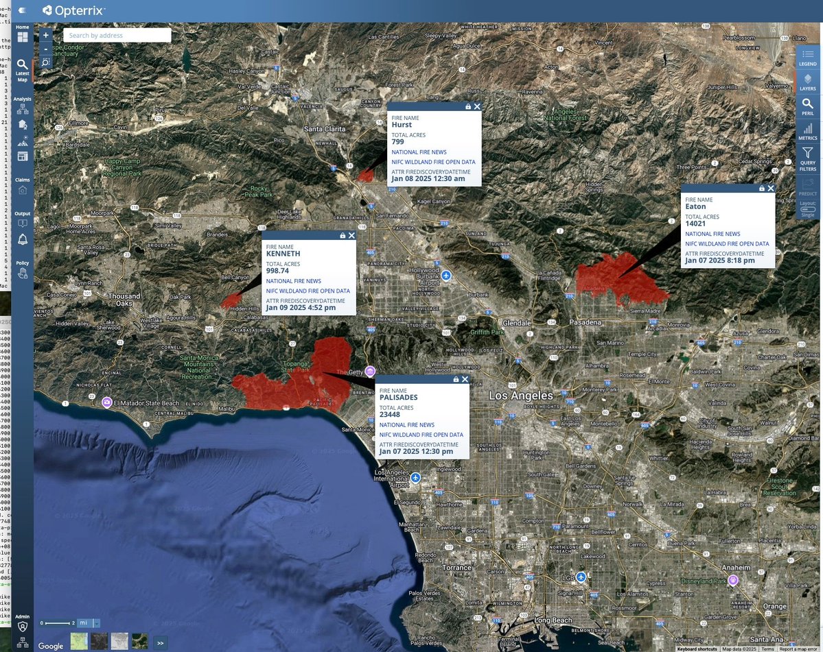
Day 15 of #30DayMapChallenge: Fire This map shows the devastating wildfires that swept through Los Angeles in January 2025, marking one of the most destructive fire events in California's history. #Wildfire #GeospatialAnalysis #DisasterResponse #DataVisualization #Opterrix


Tutorial Link: 34th Batch Master Remote Sensing with Google Earth Engine (Beginner to Advanced) The link: youtube.com/live/lGfSSKZ2n… #RemoteSensing #GoogleEarthEngine #GeospatialAnalysis #GIS #DataScience #EarthObservation #SatelliteImagery #EnvironmentalMonitoring


(Open Access) Geospatial Analysis with Python: freecomputerbooks.com/Geospatial-Ana… Look for "Read and Download Links" section to download. Follow me if you like this post. #GIS #GeospatialAnalysis #Python #programming #SpatialAnalysis #SpatialData #GeospatialData
🚨 Call for Papers! 🚨 Our special issue, "Assessing Land Subsidence Using Remote Sensing Data," in @Land_MDPI, has an extended submission deadline of March 31, 2025. Submit your research on #RemoteSensing, #LandSubsidence, and #GeospatialAnalysis. 🌍📊 #EarthObservation
Crop Type Classification with Machine Learning & Ground Truth Data Tutorial Link: youtube.com/live/S9no403GT… For more information about registration, visit our website: studyhacksgeospatial.com/google-earth-e… #MachineLearning #GeospatialAnalysis #RemoteSensing #GoogleEarthEngine #GIS
Join me on a journey into the fascinating world of #GeospatialAnalysis using #QGIS! Discover advanced techniques, real-world applications, and the power of open-source GIS. Let's map our future together! #YouthMappers #GIS @YMsummitUganda @youthmappers

80% of data whispers location secrets! DeepSpatial unlocks the power of geospatial AI, transforming whispers into impactful decisions for a future shaped by location. #ai #geospatial #geospatialanalysis #datadriven #futuretech #innovation #GeoAIFuture $DSAI $DSAIF $DSAI.CN

Stay Ahead of the Competition! Gain the insights you need to outpace your competitors and drive growth. Our data-driven insights and strategic analysis empower you to make the best decisions for your business. #ai #geospatial #geospatialanalysis #datadriven $DSAI $DSAIF $DSAI.CN

Anabranch is proud to support development of the open source QGIS platform, an essential part of our geospatial analysis and cartographic toolkit. The price ain’t bad either! #GIS #geospatialanalysis

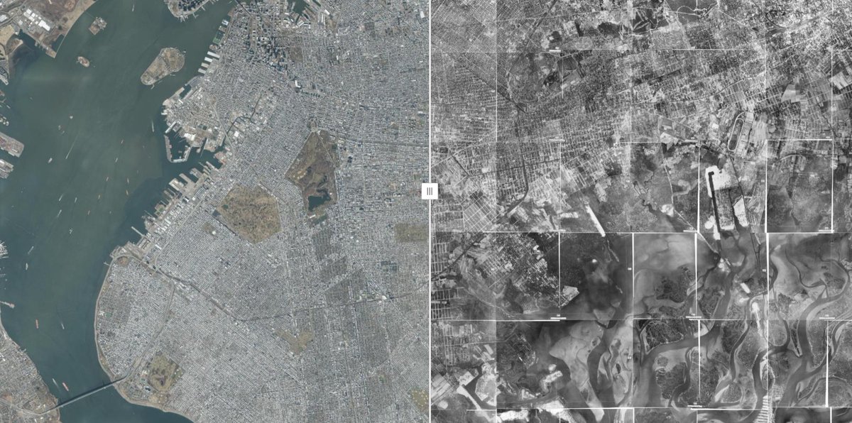
🚀 TOP 25 Coolest GIS Visualization Tools! 🌍 ✨Number 1: NYC Then & Now 👉 #GIS #DataVisualization #GeospatialAnalysis #MappingTools nyc.maps.arcgis.com/apps/instant/m…
Read the April issue Methods and Techniques for Skin Research Article from Tran et al: Applications and Best Practices for #geospatialanalysis Research in #dermatology doi.org/10.1016/j.jid.… #dermtwitter #dermatology #dermresearch

Building useful #tourismdata for your travel app? Xtract.io provides POI data for over 400 malls across the European Union. The dataset helps improve user experience by enhancing location discovery and recommendations. #geospatialanalysis zurl.co/aOBnq


Turn raw data into insights with ERDAS APOLLO: • Automate workflows • Deploy models easily • Extract actionable insights Watch the webinar to learn more: bit.ly/4bWy0qL #ERDASAPOLLO #GeospatialAnalysis

(Legally FREE) Geospatial Analysis: A Comprehensive Guide to Principles, Techniques and Software Tools - freecomputerbooks.com/Geospatial-Ana… Look for "Read and Download Links" section to download. Follow me if you like this. #GeospatialAnalysis #GIS #SpatialAnalysis #SpatialData #ArcGIS,

Geospatial Analysis: A Comprehensive Guide to Principles, Techniques and Software Tools - lnkd.in/eixapGme Look for "Read and Download Links" section to download. Follow me if you like this. #GeospatialAnalysis #GeospatialData #GIS #SpatialAnalysis #SpatialData #statistics

If you’re a beginner Python developer, GIS professional, data scientist, or urban planner, mastering Python’s geospatial capabilities can significantly enhance your toolkit. pyoflife.com/interactive-ma… #DataScience #pythonprogramming #geospatialanalysis #DataScientists #dataviz
Day 15 of #30daymapchallenge - OSM! A simple visualizing of built up areas across various countries in Oceania #cartography #geospatialanalysis #dataanalysis #GIS #urbanplanning #urbandesign

Assistant Professor of Geospatial Analysis owlindex.com/service-explor… #Owlindex #GeospatialAnalysis #VCU #EnvironmentalStudies #HigherEd #AcademicJobs #FacultyPosition #DataScience #GIS #Sustainability #ResearchOpportunity

Something went wrong.
Something went wrong.
United States Trends
- 1. #RiyadhSeason 15K posts
- 2. Mason 38.7K posts
- 3. Syracuse 8,372 posts
- 4. Lincoln Riley 1,623 posts
- 5. #AEWFullGear 7,507 posts
- 6. #AEWTailgateBrawl 2,239 posts
- 7. Oregon 28.3K posts
- 8. Kansas State 3,470 posts
- 9. Arch Manning 3,402 posts
- 10. #TheRingIV 4,397 posts
- 11. Joe Jackson 1,204 posts
- 12. Georgia Tech 2,765 posts
- 13. Stoops 1,767 posts
- 14. Avery Johnson N/A
- 15. Bam Rodriguez 1,796 posts
- 16. #GoBlue 2,584 posts
- 17. Vandy 3,494 posts
- 18. Arkansas 10.2K posts
- 19. K-State 1,320 posts
- 20. Utes 1,084 posts