#spatialdataanalysis resultados de búsqueda

🎉 Bienvenue chez #SpatialDataAnalysis (SDA) ! 🌍📊 Nous sommes ravis de lancer notre réseau dédié à l’analyse de données spatiales au service du développement durable. 🌱 Qui sommes-nous ? #SpatialDataAnalysis regroupe des experts en Geomatique et conception& gestion de projet


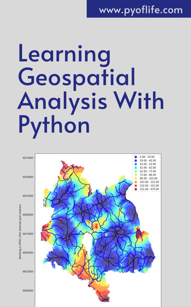
Amidst this digital landscape, Python emerges as a powerful tool, enabling enthusiasts and professionals alike to unlock the secrets hidden within geographical data. pyoflife.com/learning-geosp… #DataScience #pythonprogramming #SpatialDataAnalysis #datavisualizations #DataScientist

🌍 Exploring the world one data point at a time with #SpatialDataAnalysis in R! 🗺️ From mapping to geostatistics, R empowers us to unlock insights hidden in our spatial data. pyoflife.com/applied-spatia… #DataScience #RStats #GIS #DataAnalytics #dataviz #DataScientists


𝗩𝗮𝗹𝗲𝗿𝗶𝗲𝗽𝗶𝗲𝗿𝗶𝘀 𝗰𝗶𝗿𝗰𝗹𝗲 #SpatialDataAnalysis | #GeoSpatial A figure drawn on the Earth's surface such that the majority of the human population lives within its interior i.e., more people living INSIDE THE CIRCLE than outside of it. [Pic:1] — Ken Myers' version
![Thetaofzeta's tweet image. 𝗩𝗮𝗹𝗲𝗿𝗶𝗲𝗽𝗶𝗲𝗿𝗶𝘀 𝗰𝗶𝗿𝗰𝗹𝗲
#SpatialDataAnalysis | #GeoSpatial
A figure drawn on the Earth's surface such that the majority of the human population lives within its interior i.e., more people living INSIDE THE CIRCLE than outside of it.
[Pic:1] — Ken Myers' version](https://pbs.twimg.com/media/GOOu0dLasAAUbsR.jpg)
In a world increasingly reliant on data-driven decision-making, the realm of geospatial analysis stands as a beacon of insight, offering a unique perspective on our surroundings. pyoflife.com/learning-geosp… #DataScience #pythonprogramming #SpatialDataAnalysis #datavisualization

A groundbreaking solution automates spatial data analysis, saving time and resources.#SpatialDataAnalysis #EfficiencyBoost #AutomatedInsights #DataRevolution #TechnologicalAdvancements #OptimizedAnalysis #AI #LowCode #DigitalTransformation #IntelligentDocumentProcessing #Analytic


Coneixem les solucions de #BusinessIntelligence d’@AnalyticsStrato que fa reports geolocalitzats aplicant el #SpatialDataAnalysis per ajudar les persones emprenedores del petit comerç i el sector serveis. #BoostingMobile #4YFN20


Get to know us!! #gis #gissolutions #spatialdataanalysis #buisness #buisnessdevelopment #training #gistraining #software #softwaredevelopment


Mastering Spatial Data Analysis for Smarter Decision Making Learn to analyze spatial data and make smarter, data-driven decisions with expert guidance datamites.com/blog/mastering… #DataAnalyticsCourse #SpatialDataAnalysis #DatamitesDataAnalyticsCourse #DatamitesInstitute

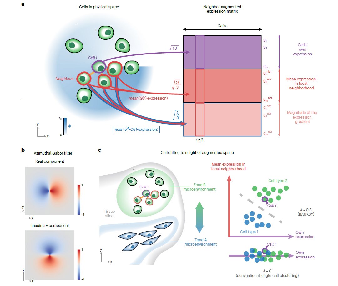
🎨Check out the new #Publication in @NatureGenet from researchers at @ASTARsg showcasing #SpatialDataAnalysis of #MERSCOPE data releases with the #BANKSY #Algorithm!💻 Learn more today: hubs.ly/Q02n09s40 #ComputationalBiology #Bioinformatics #MERFISH #AcademicTwitter
#Insurance #PredictiveAnalytics #SpatialDataAnalysis Harvey is a catastrophe, but analytics will help insurers dig-in.com/news/harvey-is…


Spatial Manager v9 Released, Supports AutoCAD, ZWCAD, GstarCAD 2024 and BricsCAD 24 dailycadcam.com/spatial-manage… via @dailycadcam @SpatialManager #SpatialManager_v9 #SpatialDataAnalysis #Geospatial #plugin #AutoCAD #ZWCAD #GstarCAD #BricsCAD


RT Why Data Scientists Should Decluster Their Geospatial Datasets dlvr.it/RnKV7q #spatialdataanalysis #videotutorial #declustering #datavisualization

Coneixem les solucions de #BusinessIntelligence d’@AnalyticsStrato que fa reports geolocalitzats aplicant el #SpatialDataAnalysis per ajudar les persones emprenedores del petit comerç i el sector serveis. 👉 stratoanalytics.es


🏢 A data center is a facility housing computer systems and related components for data storage and management. GIBS services raise its capabilities with spatial data analysis, supporting advanced decision-making and operations. #DataCenter #SpatialDataAnalysis #ITService


#spatialdataanalysis How GPS Satellites Analyze Population Growth Every Day computerkeyboardpicture.com/the-worlds-pop…

🚀 Call for Papers: Special Issue on "Algorithms and Application for Spatiotemporal Data Processing" 🧠 📚 Guest Editor: Prof. Dr. Di Zhang 🔍 Explore the full details and submission guidelines here: mdpi.com/journal/algori… #spatialdataanalysis #geodesyandsurveyingengineering


#spatialdataanalysis Why Is Population Analysis An Important Tool For The Economy? computerkeyboardpicture.com/the-worlds-pop…
Bentley’s Subsidiary Seequent Acquires Denver-based Geostatistical Software Applications Developer AR2Tech dailycadcam.com/infrastructure… via @dailycadcam @BentleySystems @Seequentglobal @AR2TechNews #Geostatistics #Geomodeling #SpatialDataAnalysis #Infrastructure

Mastering Spatial Data Analysis for Smarter Decision Making Learn to analyze spatial data and make smarter, data-driven decisions with expert guidance datamites.com/blog/mastering… #DataAnalyticsCourse #SpatialDataAnalysis #DatamitesDataAnalyticsCourse #DatamitesInstitute
Amidst this digital landscape, Python emerges as a powerful tool, enabling enthusiasts and professionals alike to unlock the secrets hidden within geographical data. pyoflife.com/learning-geosp… #DataScience #pythonprogramming #SpatialDataAnalysis #datavisualizations #DataScientist
In a world increasingly reliant on data-driven decision-making, the realm of geospatial analysis stands as a beacon of insight, offering a unique perspective on our surroundings. pyoflife.com/learning-geosp… #DataScience #pythonprogramming #SpatialDataAnalysis #datavisualization
🚀 Call for Papers: Special Issue on "Algorithms and Application for Spatiotemporal Data Processing" 🧠 📚 Guest Editor: Prof. Dr. Di Zhang 🔍 Explore the full details and submission guidelines here: mdpi.com/journal/algori… #spatialdataanalysis #geodesyandsurveyingengineering

PhD researcher @davidelomeo used #satellite #RemoteSensing & #SpatialDataAnalysis to discover extreme #cyanobacteria blooms across 20 waterholes in #Botswana, where 350 African elephants died in 2020, sparking global concern. Follow Davide for more & read coverage in @guardian 👇

Our article has featured in The Guardian! #conservation #cyanobacteria #kcl #esa #elephants theguardian.com/environment/20…


Daha fazla bilgi: [intechopen.com/welcome/36b039…] #Geoinformatics #AdvancedGeoinformatics #SpatialDataAnalysis #EarthSciences
🏢 A data center is a facility housing computer systems and related components for data storage and management. GIBS services raise its capabilities with spatial data analysis, supporting advanced decision-making and operations. #DataCenter #SpatialDataAnalysis #ITService
𝗩𝗮𝗹𝗲𝗿𝗶𝗲𝗽𝗶𝗲𝗿𝗶𝘀 𝗰𝗶𝗿𝗰𝗹𝗲 #SpatialDataAnalysis | #GeoSpatial A figure drawn on the Earth's surface such that the majority of the human population lives within its interior i.e., more people living INSIDE THE CIRCLE than outside of it. [Pic:1] — Ken Myers' version

"It's just a filter bro" the Noisia filter: real-time .cube LUT parsing & application with 8-corner sampling + rgba interpolation + dithering algorithm + luminance-aware film grain simulation + distance-based vignette with adjustable falloff intensity + blending, all on a…


#Python for #Geospatial Data Analysis: amzn.to/3DNT2bC ————— #Analytics #DataScience #Geoscience #LocationIntelligence #GIS #Geoinformatics #AI #MachineLearning #DataScientist #SpatialAnalysis #Coding


Online tools to identify a location from an uploaded photo using AI: geospy.web.app earthkit.app usersearch.org (GeoSpy integration) picarta.ai labs.tib.eu/geoestimation/ GeoGuessr GPT chatgpt.com/g/g-brlHi7t2R-…


Architecture offers built-in frames for the world around us. Have a photo that uses structure in a similar way? Share it below. Discover more here: vs.co/Jg7o/hb44qic0 Images by miguelsainz and saosyant


🎉 Bienvenue chez #SpatialDataAnalysis (SDA) ! 🌍📊 Nous sommes ravis de lancer notre réseau dédié à l’analyse de données spatiales au service du développement durable. 🌱 Qui sommes-nous ? #SpatialDataAnalysis regroupe des experts en Geomatique et conception& gestion de projet

High-resolution satellite images can be insanely expensive to buy. So here's a list of free datasets you can access. These datasets can be used to build foundation models, super-resolution models, or for segmentation.

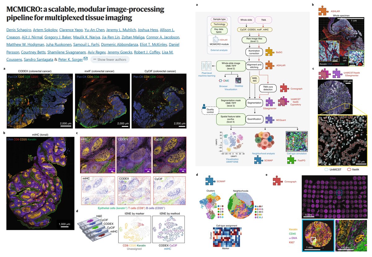
#SpatialOmics MCMICRO Multiple Choice Microscopy pipeline mcmicro.org Multi-channel whole-slide images▶️ Single-cell data BaSiC▶️Illumination correction ASHLAR-▶️Tile stitch & alignment Coreograph▶️TMA core detection UnMICST Cypository Ilastik S3segmenter▶️…


Amidst this digital landscape, Python emerges as a powerful tool, enabling enthusiasts and professionals alike to unlock the secrets hidden within geographical data. pyoflife.com/learning-geosp… #DataScience #pythonprogramming #SpatialDataAnalysis #datavisualizations #DataScientist
🌍 Exploring the world one data point at a time with #SpatialDataAnalysis in R! 🗺️ From mapping to geostatistics, R empowers us to unlock insights hidden in our spatial data. pyoflife.com/applied-spatia… #DataScience #RStats #GIS #DataAnalytics #dataviz #DataScientists
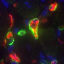
🎨Check out the new #Publication in @NatureGenet from researchers at @ASTARsg showcasing #SpatialDataAnalysis of #MERSCOPE data releases with the #BANKSY #Algorithm!💻 Learn more today: hubs.ly/Q02n09s40 #ComputationalBiology #Bioinformatics #MERFISH #AcademicTwitter

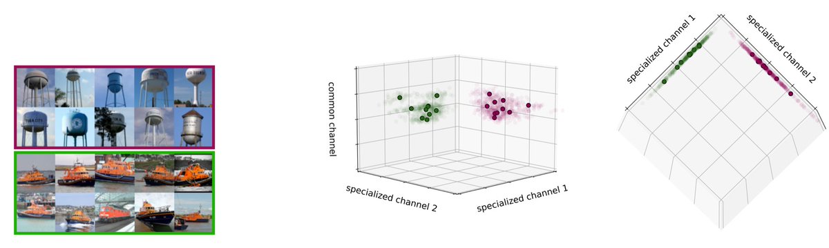
Within each subspace lies a cluster of image representations that are semantically similar.

This should be impossible! With only 3 lines, this open-source library finds every bad image in your dataset: • Blurry • Under/over-exposed • Oddly sized • Duplicates If you are into AI/ML, star this repo: github.com/cleanlab/clean…. They are building incredible things!


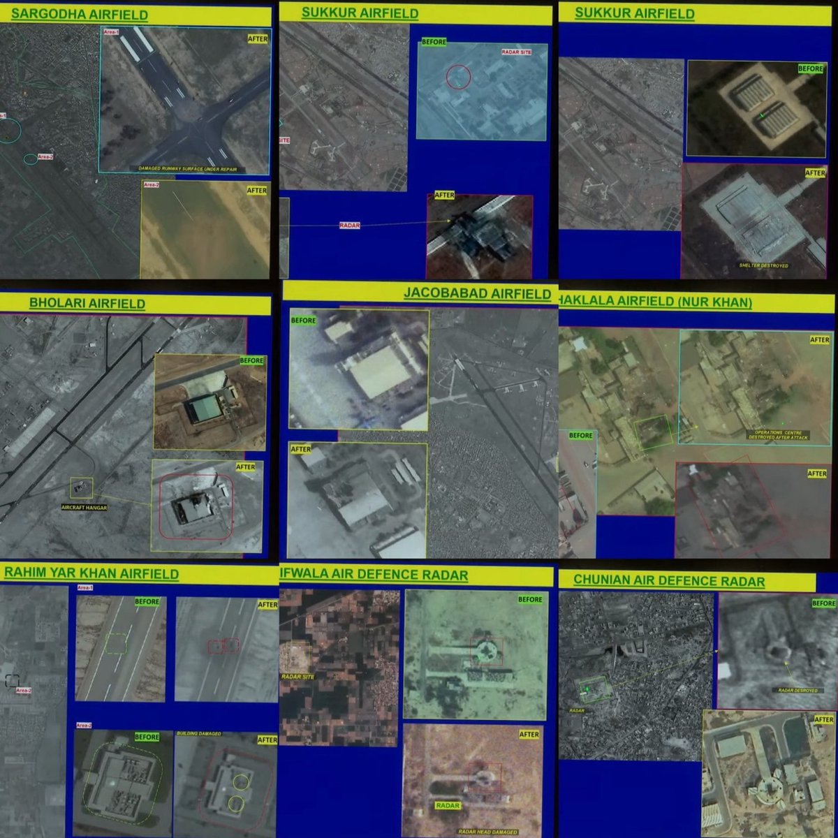
Sat images analysis time! I'll be giving my take on the sat images given by India. You might have seen this image mostly on X these days 🧵👇🏻

See your business in a new light. Our AI-powered maps turn complex data into simple, actionable visuals. #DataStrategy #Analytics

A groundbreaking solution automates spatial data analysis, saving time and resources.#SpatialDataAnalysis #EfficiencyBoost #AutomatedInsights #DataRevolution #TechnologicalAdvancements #OptimizedAnalysis #AI #LowCode #DigitalTransformation #IntelligentDocumentProcessing #Analytic
In a world increasingly reliant on data-driven decision-making, the realm of geospatial analysis stands as a beacon of insight, offering a unique perspective on our surroundings. pyoflife.com/learning-geosp… #DataScience #pythonprogramming #SpatialDataAnalysis #datavisualization
Coneixem les solucions de #BusinessIntelligence d’@AnalyticsStrato que fa reports geolocalitzats aplicant el #SpatialDataAnalysis per ajudar les persones emprenedores del petit comerç i el sector serveis. #BoostingMobile #4YFN20
Something went wrong.
Something went wrong.
United States Trends
- 1. Stanford 9,547 posts
- 2. #AEWWrestleDream 66.5K posts
- 3. Florida State 9,336 posts
- 4. Mike Norvell 1,126 posts
- 5. sabrina 61.6K posts
- 6. #byucpl N/A
- 7. Darby 10.9K posts
- 8. Hugh Freeze 2,966 posts
- 9. Utah 31.9K posts
- 10. Lincoln Riley 2,773 posts
- 11. Mizzou 6,143 posts
- 12. Bama 16.3K posts
- 13. Castellanos 3,726 posts
- 14. Kentucky 25.1K posts
- 15. Sperry N/A
- 16. Arch 25.8K posts
- 17. Nobody's Son 2,412 posts
- 18. Stoops 4,989 posts
- 19. #RollTide 9,234 posts
- 20. Sark 4,567 posts