#spatialdataanalysis risultati di ricerca

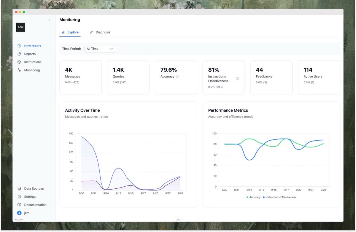
This website is literally helps you Analyze Data with just prompts😳 It is an open-source AI Analyst that allows you: •Chat with your data warehouse •Generate SQL & Python code from questions •Auto-build Excel dashboards •Centralize metric definitions 🧵

Want to understand what Spatial Transcriptomics (ST) is,but unsure where to start? Need to analyze spatial genomics data,but unclear how? Here's how to start👇 An introductory #Bioinformatics review on: 1. ST Technologies 2. Exploratory data analysis 3. Biological implications


🎉 Bienvenue chez #SpatialDataAnalysis (SDA) ! 🌍📊 Nous sommes ravis de lancer notre réseau dédié à l’analyse de données spatiales au service du développement durable. 🌱 Qui sommes-nous ? #SpatialDataAnalysis regroupe des experts en Geomatique et conception& gestion de projet


💡Lo que TODO analista de datos debería saber: conceptos, errores y modelos explicados.🤯 No basta con software o IA: comprender la estadística marca la diferencia entre resultados fiables y engañosos. Recopilatorio de post importantes👇🧵 #DataScience #Stats #RStats #analytics


Internet access unlocks economic and educational opportunities. Using (free) geospatial data, we can now identify which areas lack internet access at super granular levels. Here's the breakdown:


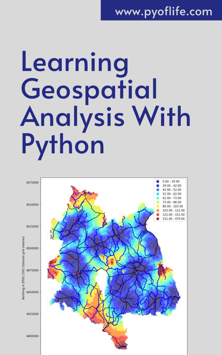
Amidst this digital landscape, Python emerges as a powerful tool, enabling enthusiasts and professionals alike to unlock the secrets hidden within geographical data. pyoflife.com/learning-geosp… #DataScience #pythonprogramming #SpatialDataAnalysis #datavisualizations #DataScientist

Everything you need to know about spatial autocorrelation. PLUS: how to access free high-res satellite data, how super-resolution uses game theory, how to properly use Google Trends data, and more. Here's everything I wrote about last week:

🌍 Exploring the world one data point at a time with #SpatialDataAnalysis in R! 🗺️ From mapping to geostatistics, R empowers us to unlock insights hidden in our spatial data. pyoflife.com/applied-spatia… #DataScience #RStats #GIS #DataAnalytics #dataviz #DataScientists


𝗩𝗮𝗹𝗲𝗿𝗶𝗲𝗽𝗶𝗲𝗿𝗶𝘀 𝗰𝗶𝗿𝗰𝗹𝗲 #SpatialDataAnalysis | #GeoSpatial A figure drawn on the Earth's surface such that the majority of the human population lives within its interior i.e., more people living INSIDE THE CIRCLE than outside of it. [Pic:1] — Ken Myers' version
![Thetaofzeta's tweet image. 𝗩𝗮𝗹𝗲𝗿𝗶𝗲𝗽𝗶𝗲𝗿𝗶𝘀 𝗰𝗶𝗿𝗰𝗹𝗲
#SpatialDataAnalysis | #GeoSpatial
A figure drawn on the Earth's surface such that the majority of the human population lives within its interior i.e., more people living INSIDE THE CIRCLE than outside of it.
[Pic:1] — Ken Myers' version](https://pbs.twimg.com/media/GOOu0dLasAAUbsR.jpg)

Optimize space, reduce costs, and plan smarter with AI Spatial Intelligence for Measurement & Planning. Detect objects, calculate occupied area, and streamline operations for real estate, warehouses, & logistics. thirdeyedata.ai/ai-spatial-int… #AI #SpatialIntelligence #ComputerVision

In a world increasingly reliant on data-driven decision-making, the realm of geospatial analysis stands as a beacon of insight, offering a unique perspective on our surroundings. pyoflife.com/learning-geosp… #DataScience #pythonprogramming #SpatialDataAnalysis #datavisualization

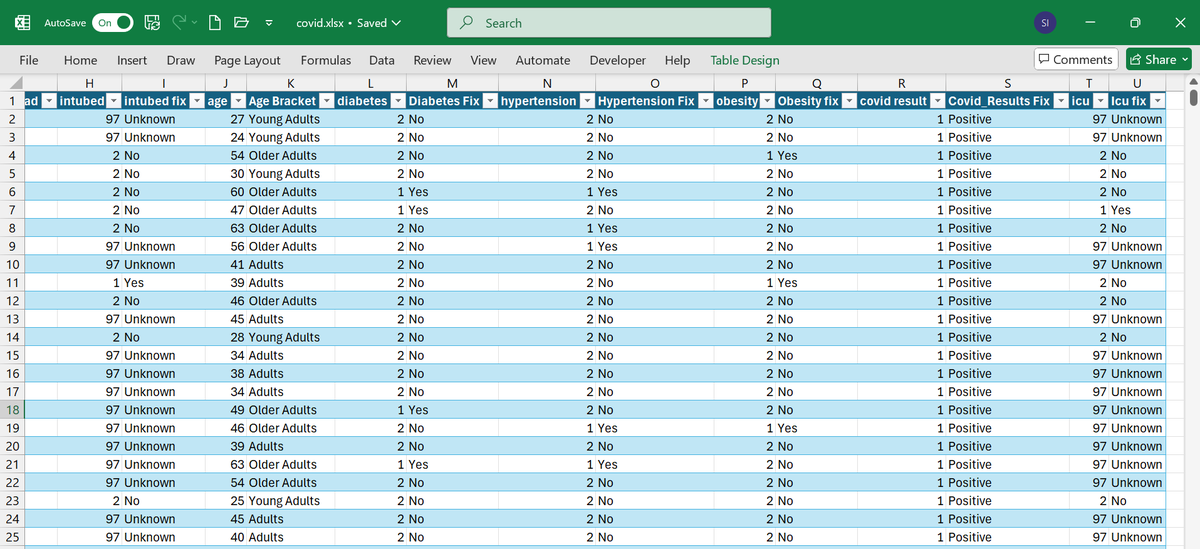
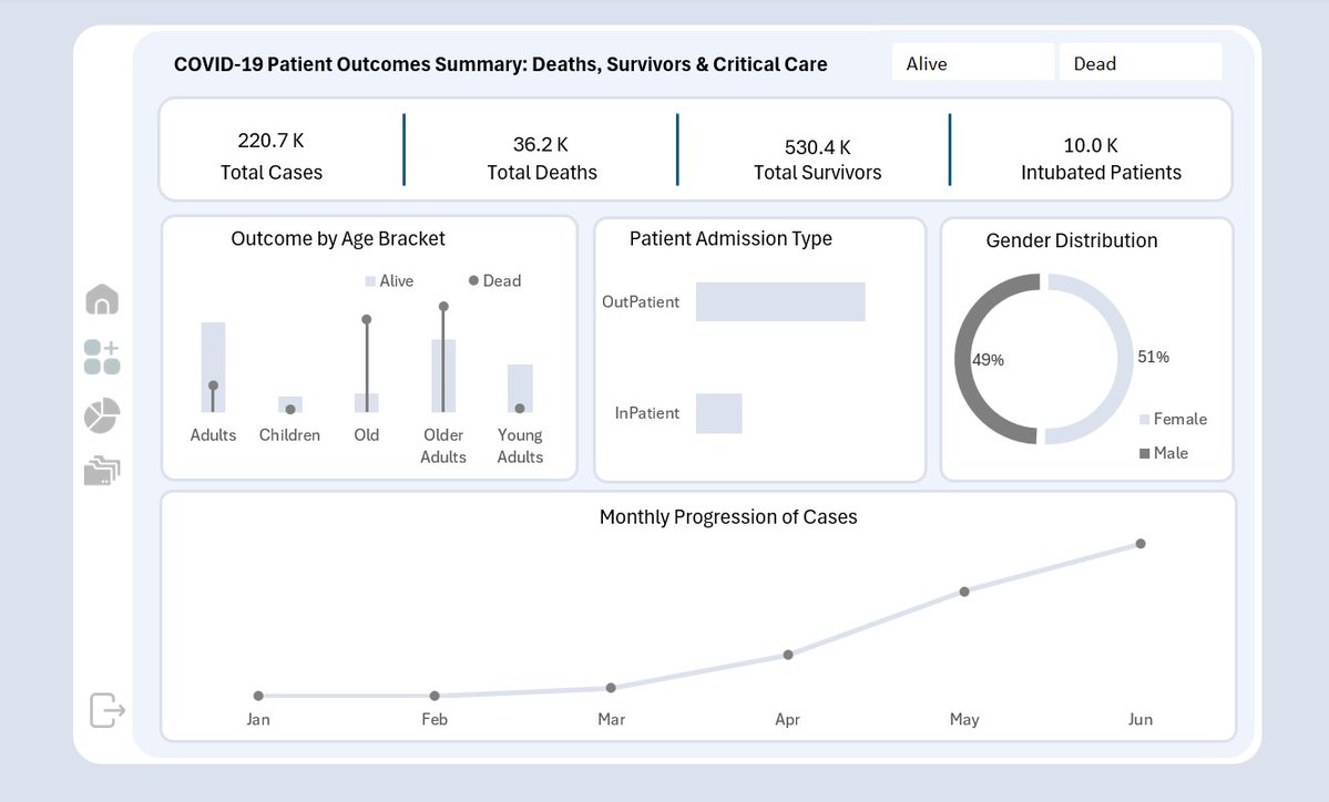
Progress update on my COVID-19 Excel Dashboard project. I’ve completed the pivot table structure; analyzing confirmed cases, deaths, survivors, ICU admissions, intubations, and comorbidity impact across different age groups and patient types.

Data Cleaning & Preparation The COVID-19 dataset underwent several cleaning and transformation steps to ensure consistency and accuracy. Missing or unknown values (e.g., 97, 98, 99) in categorical columns such as Intubed, ICU, Diabetes, Hypertension, and Obesity were identified


🗺️ Analyzing location data at scale just got easier. Databricks Spatial SQL lets you work with native GEOMETRY and GEOGRAPHY types, run over 80 built-in SQL functions, and perform spatial joins without manual indexing. Now in public preview: databricks.com/blog/introduci…

#Python for #Geospatial Data Analysis: amzn.to/3DNT2bC ————— #Analytics #DataScience #Geoscience #LocationIntelligence #GIS #Geoinformatics #AI #MachineLearning #DataScientist #SpatialAnalysis #Coding


Multiple Location Remote Job 🚨 Role: Data Analyst Est Salary: $21 per hour Location: Remote - Identify, analyze, and resolve data inconsistencies - Collaborate with team members Let us know if you are Interested 👇
This analysis shows how data can drive better healthcare decisions and save lives. #Excel #Healthcareanalysis #Covid19

How did age, health conditions, and critical care affect COVID-19 survival? I analyzed patient demographics and risk factors to understand who was most affected and why some recovered while others didn’t. Here’s what the data revealed:


I've sketched a region map - now your turn to add some locations and features into it. Waiting for your comments. I'll try to add the most liked and not-too-crazy ones!


See your business in a new light. Our AI-powered maps turn complex data into simple, actionable visuals. #DataStrategy #Analytics


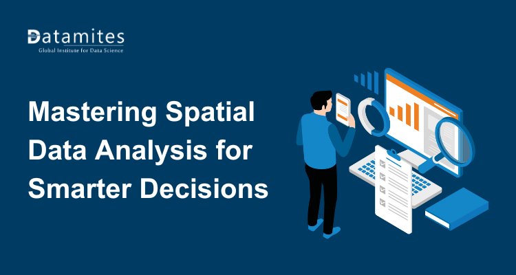
Mastering Spatial Data Analysis for Smarter Decision Making Learn to analyze spatial data and make smarter, data-driven decisions with expert guidance datamites.com/blog/mastering… #DataAnalyticsCourse #SpatialDataAnalysis #DatamitesDataAnalyticsCourse #DatamitesInstitute
Amidst this digital landscape, Python emerges as a powerful tool, enabling enthusiasts and professionals alike to unlock the secrets hidden within geographical data. pyoflife.com/learning-geosp… #DataScience #pythonprogramming #SpatialDataAnalysis #datavisualizations #DataScientist
In a world increasingly reliant on data-driven decision-making, the realm of geospatial analysis stands as a beacon of insight, offering a unique perspective on our surroundings. pyoflife.com/learning-geosp… #DataScience #pythonprogramming #SpatialDataAnalysis #datavisualization

🚀 Call for Papers: Special Issue on "Algorithms and Application for Spatiotemporal Data Processing" 🧠 📚 Guest Editor: Prof. Dr. Di Zhang 🔍 Explore the full details and submission guidelines here: mdpi.com/journal/algori… #spatialdataanalysis #geodesyandsurveyingengineering


PhD researcher @davidelomeo used #satellite #RemoteSensing & #SpatialDataAnalysis to discover extreme #cyanobacteria blooms across 20 waterholes in #Botswana, where 350 African elephants died in 2020, sparking global concern. Follow Davide for more & read coverage in @guardian 👇

Our article has featured in The Guardian! #conservation #cyanobacteria #kcl #esa #elephants theguardian.com/environment/20…


Daha fazla bilgi: [intechopen.com/welcome/36b039…] #Geoinformatics #AdvancedGeoinformatics #SpatialDataAnalysis #EarthSciences

🏢 A data center is a facility housing computer systems and related components for data storage and management. GIBS services raise its capabilities with spatial data analysis, supporting advanced decision-making and operations. #DataCenter #SpatialDataAnalysis #ITService

𝗩𝗮𝗹𝗲𝗿𝗶𝗲𝗽𝗶𝗲𝗿𝗶𝘀 𝗰𝗶𝗿𝗰𝗹𝗲 #SpatialDataAnalysis | #GeoSpatial A figure drawn on the Earth's surface such that the majority of the human population lives within its interior i.e., more people living INSIDE THE CIRCLE than outside of it. [Pic:1] — Ken Myers' version
🎉 Bienvenue chez #SpatialDataAnalysis (SDA) ! 🌍📊 Nous sommes ravis de lancer notre réseau dédié à l’analyse de données spatiales au service du développement durable. 🌱 Qui sommes-nous ? #SpatialDataAnalysis regroupe des experts en Geomatique et conception& gestion de projet
🌍 Exploring the world one data point at a time with #SpatialDataAnalysis in R! 🗺️ From mapping to geostatistics, R empowers us to unlock insights hidden in our spatial data. pyoflife.com/applied-spatia… #DataScience #RStats #GIS #DataAnalytics #dataviz #DataScientists

Coneixem les solucions de #BusinessIntelligence d’@AnalyticsStrato que fa reports geolocalitzats aplicant el #SpatialDataAnalysis per ajudar les persones emprenedores del petit comerç i el sector serveis. 👉 stratoanalytics.es


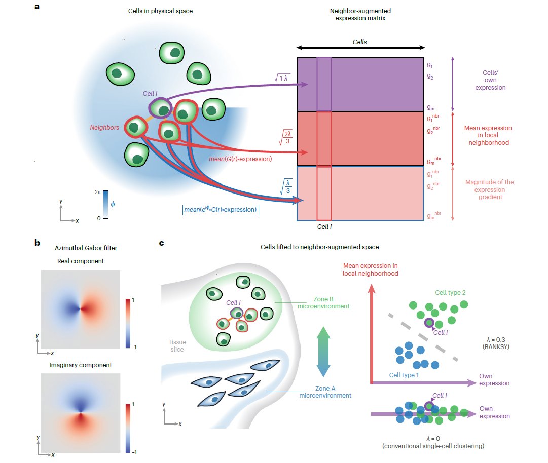
🎨Check out the new #Publication in @NatureGenet from researchers at @ASTARsg showcasing #SpatialDataAnalysis of #MERSCOPE data releases with the #BANKSY #Algorithm!💻 Learn more today: hubs.ly/Q02n09s40 #ComputationalBiology #Bioinformatics #MERFISH #AcademicTwitter

A groundbreaking solution automates spatial data analysis, saving time and resources.#SpatialDataAnalysis #EfficiencyBoost #AutomatedInsights #DataRevolution #TechnologicalAdvancements #OptimizedAnalysis #AI #LowCode #DigitalTransformation #IntelligentDocumentProcessing #Analytic


Coneixem les solucions de #BusinessIntelligence d’@AnalyticsStrato que fa reports geolocalitzats aplicant el #SpatialDataAnalysis per ajudar les persones emprenedores del petit comerç i el sector serveis. #BoostingMobile #4YFN20


RT Why Data Scientists Should Decluster Their Geospatial Datasets dlvr.it/RnKV7q #spatialdataanalysis #videotutorial #declustering #datavisualization

Amidst this digital landscape, Python emerges as a powerful tool, enabling enthusiasts and professionals alike to unlock the secrets hidden within geographical data. pyoflife.com/learning-geosp… #DataScience #pythonprogramming #SpatialDataAnalysis #datavisualizations #DataScientist
In a world increasingly reliant on data-driven decision-making, the realm of geospatial analysis stands as a beacon of insight, offering a unique perspective on our surroundings. pyoflife.com/learning-geosp… #DataScience #pythonprogramming #SpatialDataAnalysis #datavisualization

Get to know us!! #gis #gissolutions #spatialdataanalysis #buisness #buisnessdevelopment #training #gistraining #software #softwaredevelopment

𝗩𝗮𝗹𝗲𝗿𝗶𝗲𝗽𝗶𝗲𝗿𝗶𝘀 𝗰𝗶𝗿𝗰𝗹𝗲 #SpatialDataAnalysis | #GeoSpatial A figure drawn on the Earth's surface such that the majority of the human population lives within its interior i.e., more people living INSIDE THE CIRCLE than outside of it. [Pic:1] — Ken Myers' version

Spatial Manager v9 Released, Supports AutoCAD, ZWCAD, GstarCAD 2024 and BricsCAD 24 dailycadcam.com/spatial-manage… via @dailycadcam @SpatialManager #SpatialManager_v9 #SpatialDataAnalysis #Geospatial #plugin #AutoCAD #ZWCAD #GstarCAD #BricsCAD

🚀 Call for Papers: Special Issue on "Algorithms and Application for Spatiotemporal Data Processing" 🧠 📚 Guest Editor: Prof. Dr. Di Zhang 🔍 Explore the full details and submission guidelines here: mdpi.com/journal/algori… #spatialdataanalysis #geodesyandsurveyingengineering
#Insurance #PredictiveAnalytics #SpatialDataAnalysis Harvey is a catastrophe, but analytics will help insurers dig-in.com/news/harvey-is…

Bentley’s Subsidiary Seequent Acquires Denver-based Geostatistical Software Applications Developer AR2Tech dailycadcam.com/infrastructure… via @dailycadcam @BentleySystems @Seequentglobal @AR2TechNews #Geostatistics #Geomodeling #SpatialDataAnalysis #Infrastructure


Join us for an exclusive & engaging panel discussion on #ComputationalTools & Approaches to #SpatialDataAnalysis 📅 Mark your calendar: 13 September 2023 📍 Location: Amsterdam 📖 Agenda: hubs.la/Q01XT8Q00 #OmicsSeries23 #SpatialBiologyEurope2023

🏢 A data center is a facility housing computer systems and related components for data storage and management. GIBS services raise its capabilities with spatial data analysis, supporting advanced decision-making and operations. #DataCenter #SpatialDataAnalysis #ITService

Get spatial data in a jiffy for more accurate results. 👉 Need more insight? 🌏 Get more at quadric.app #spatialdataanalysis #geospatialdata #QuadripMaps #BusinessAutomation #Quadric #Business #Tools #Automation #FieldData

Something went wrong.
Something went wrong.
United States Trends
- 1. No Kings 881K posts
- 2. Carnell Tate 4,877 posts
- 3. Vandy 12.1K posts
- 4. Brian Kelly 6,606 posts
- 5. Vanderbilt 9,680 posts
- 6. Diego Pavia 3,953 posts
- 7. #UFCVancouver 6,648 posts
- 8. Beamer 3,259 posts
- 9. Tony Vitello 3,213 posts
- 10. Dork Cult Protest Day 45.9K posts
- 11. Clark Lea 1,126 posts
- 12. Ole Miss 8,277 posts
- 13. Cash Jones N/A
- 14. South Carolina 11.1K posts
- 15. Sorokin N/A
- 16. Shula 2,751 posts
- 17. Julian Sayin 1,247 posts
- 18. Constitutional Republic 18.9K posts
- 19. Nuss 3,395 posts
- 20. #GoBlue 2,675 posts