#webmap نتائج البحث

Now we’re making web maps #arcgis #arcgisonline #webmap #sysadmin #esritraining #esri #esrigram #workingstudent @EsriTraining
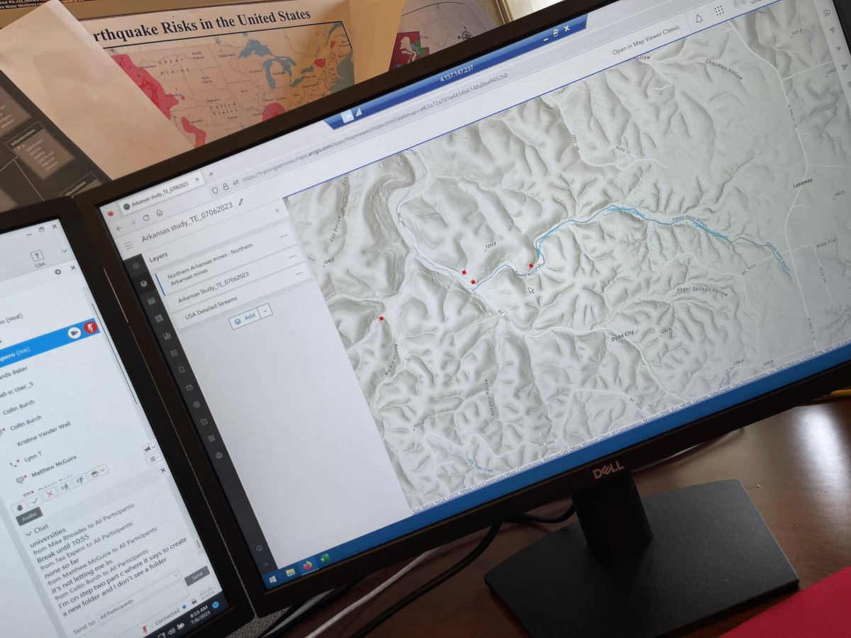
Home stretch on the training from @EsriTraining #arcgis #arcgisonline #webmap #sysadmin #esritraining #esri #esrigram #workingstudent


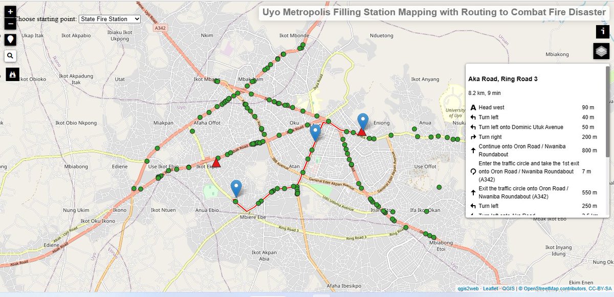
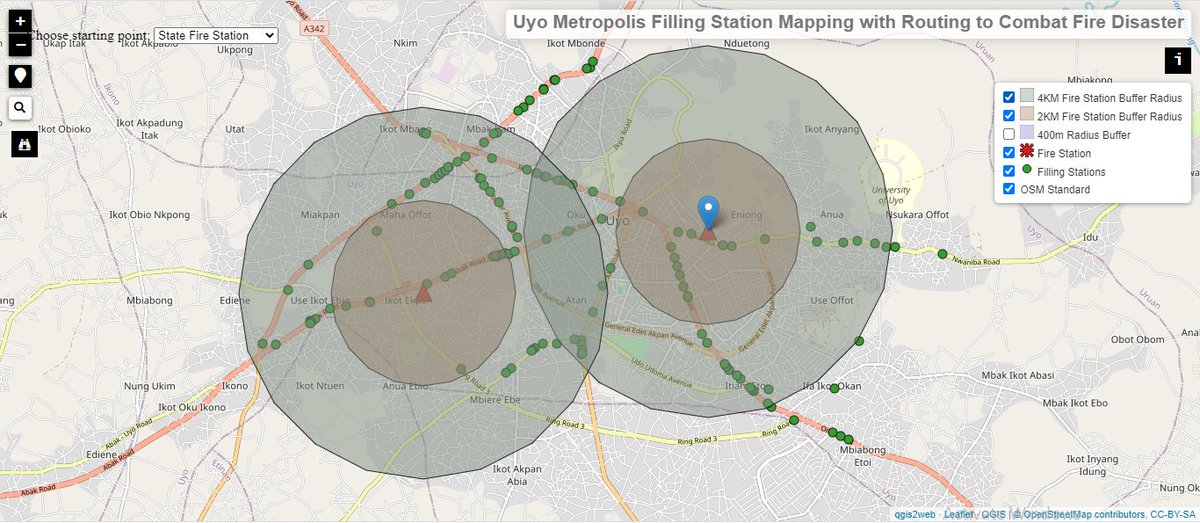
Webmap of Uyo, Akwa Ibom State, displaying filling stations and two fire stations, with embedded routing for efficient response during fire emergencies—a practical example of disaster management mapping. #GIS #gischat #webmap #disater_management #DataScience #DataAnalytics


Mapmakers of twitter! Post your favorite maps you’ve made, I’ll start


Put your raster #GIS files on the web with our new easy-to-use upload facility. You’ll have your data ready to put into a #webmap in no time at all! Read more here: maptiler.link/3XNudGL

Here's a fun GL JS example: Orient a map's markers to the horizon. Add this 3D effect to Mapbox globe to make your map that much more dynamic. 😲 Explore how on our GL JS Docs: buff.ly/3JyZNAr #webmap #mapdesign


The OneCity Explorer was developed by @MGIMona Interact with the OneCity Explorer here: arcgis.com/apps/dashboard… #OneCity #WebMap

Bon voyage! 🛩️ Use this example to learn how to filter UI elements to list only the points that are currently visible on the map (in this case, airports). No more confusing ABQ with ADQ: buff.ly/3Jckty9 #devtips #webdevelopment #webmap
Launch of OneCity Explorer. Here is the video: youtube.com/watch?v=Xdy_2M… Mapping Access to Services and Quality of Life in Jamaican Cities. @OneCityJA @CapriCaribbean #OneCity #WebMap


Just built a dashboard using Mapbox GL JS and learned about the new `map.on('idle', () => {...})` listener! I was working on a histogram chart with D3.js to display data based on the map’s viewport. @Mapbox @d3js_org #webmap #spatial #mapping


FUTA STREET GUIDE MAP PROJECT '24 A blend of geospatial science, JavaScript development, and community-driven data. Check out the awareness video. @FutaBro #GIS #WebMap #FUTA #JavaScript #SmartCampus #TechForGood #LocationIntelligence

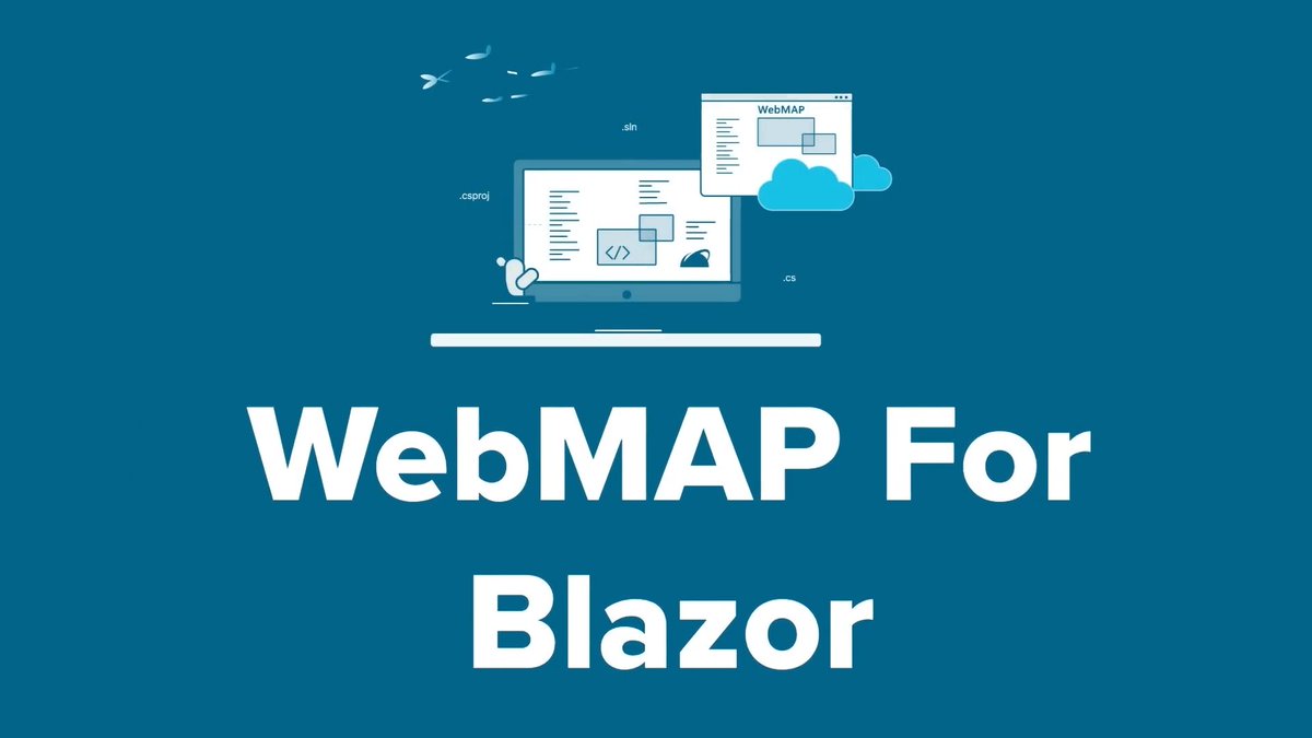
Tired of desktop-bound C# apps? Convert them to modern web experiences with GAP's WebMAP! ✨ Join our prerelease and be the first to try our automated code migration tool. hubs.li/Q02SbXMp0 #Blazor #Csharp #WebMAP #Modernization

💻🗺➡ En esta entrada se muestra cómo insertar un “widget” en tu “Web Map” creado con ArcGIS Experience Builder en AGOL. Leer más: bit.ly/widget-AGOL #WebGIS #widget #webmap #WebMapping #AGOL #ArcGISOnline

We are thrilled to announce that the GeoServer Community has featured a tutorial video from our group on the main page of the GeoServer website! The GeoSpatial Techno group extends their thanks to the GeoServer community for their support. #geoserver #openstandards #webmap #ogc


Take a minute to explore our #webmap by @AbdulFatawu_ Find more information on our website and GitHub page. Map: tekkigeo.github.io/ejisu_lulc_web…

One of the most popular examples in our Mapbox GL JS Docs is how to create clusters. These unique and dynamic visual markers are a great way to communicate data. See for yourself: buff.ly/3e4xrPu #webdeveloper #webmap #interactivemaps

Our "coalesce" expression lets developers run through a priority list of images and select the first valid option. In this example, learn to use coalesce expressions so that all of your points of interest have a fallback icon: buff.ly/3PDEZvA #webmap #webmapping

It's a big planet. Give your users a better sense of distance by adding scale to your map! Mapbox GL JS has a built-in object to take care of rendering a scale. Learn how to implement it today: buff.ly/3W5z1oo #webmap #webdeveloper #LearnToCode


GeoSpatial Training Services will offer several workshops at the 2024 MAGIP Big Sky GeoCon. Visit our website for more details and a full list of conference offerings! magip.org/BigSkyGeoCon #MontanaGIS #BigSkyGeoCon #webmap #MAGIP #GIS #Geospatial

💻🗺➡ En esta entrada se muestra cómo insertar un “widget” en tu “Web Map” creado con ArcGIS Experience Builder en AGOL. Leer más: bit.ly/widget-AGOL #WebGIS #widget #webmap #WebMapping #AGOL #ArcGISOnline


… and so much more. Thanks to our amazing team and extensive partners for a productive first half of the year doing what we love for the ecosystems we love, and keep up with our projects on our @ArcGIS #WebMap 🗺️ 🔗serc.si.edu/labs/marine-co… /end #WorldMangroveDay


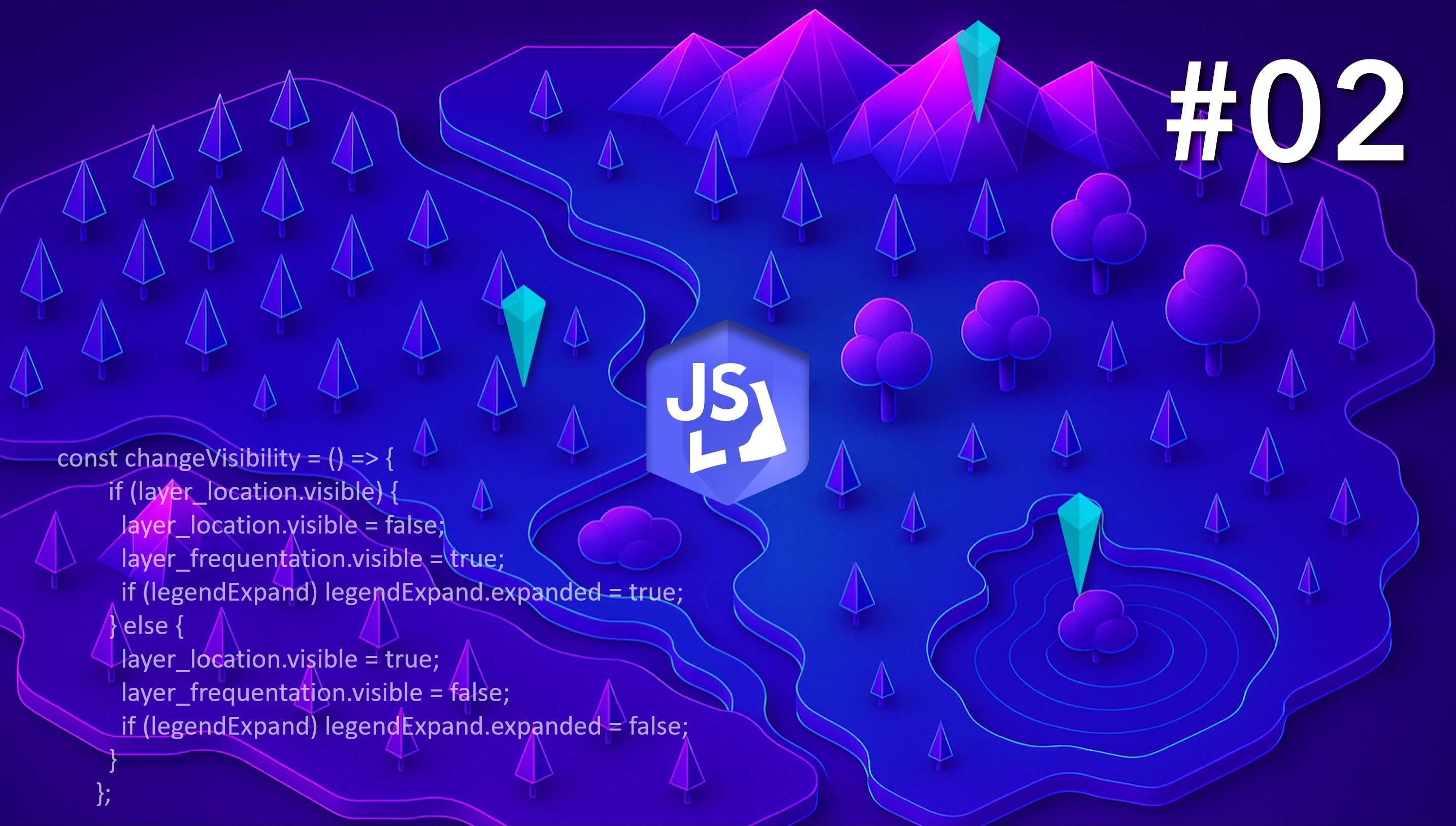
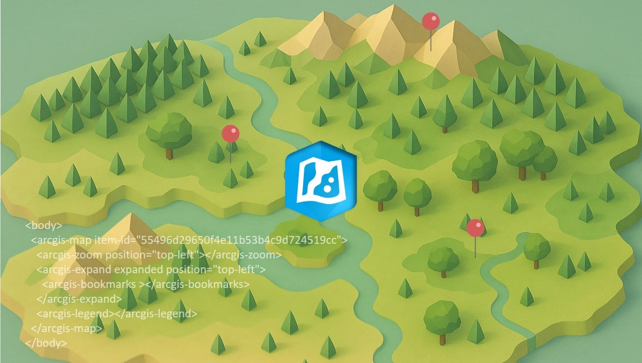
🗺️ La #webmap est une base solide et intuitive pour créer des applications dans #ArcGIS. Mais saviez-vous qu’elle peut aussi être intégrée et étendue dans vos propres apps grâce au SDK JavaScript ? Dans ce 1er article d’une mini-série en 3 volets, nous vous montrons comment…
codethemap.fr
Aller plus loin que la webmap avec le SDK JavaScript d'ArcGIS #01
Dans un article précédent , je vous faisais part des bienfaits de la webmap et de sa configuration sans code pour alléger votre...
FUTA STREET GUIDE MAP PROJECT '24 A blend of geospatial science, JavaScript development, and community-driven data. Check out the awareness video. @FutaBro #GIS #WebMap #FUTA #JavaScript #SmartCampus #TechForGood #LocationIntelligence

Dans cette mini-série, je vous montre comment utiliser le SDK #JavaScript d'#ArcGIS pour étendre la #webmap dans une app personnalisée ! Découvrez le deuxième épisode ici : codethemap.fr/2025/05/person… @Esri_France

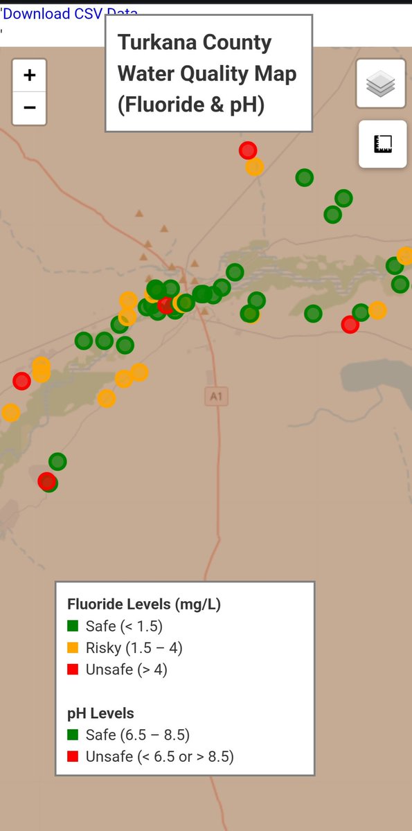
I built an interactive #WebMap showing water quality (fluoride & pH) in Turkana County, Kenya using #Python, #Folium & #GeoPandas. It helps visualize safe vs unsafe zones using real sampling data. See the project: ray-mainah.github.io/turkana-water-… #Geospatial #DataScience #WaterQuality
La #webmap est une base solide et intuitive pour créer des apps dans #ArcGIS. Mais saviez-vous qu’elle peut aussi être intégrée et étendue via le SDK JavaScript ? Je vous montre comment dans ce 1er article (1/3) : codethemap.fr/2025/05/person… @Esri_France
codethemap.fr
Aller plus loin que la webmap avec le SDK JavaScript d'ArcGIS #01
Dans un article précédent , je vous faisais part des bienfaits de la webmap et de sa configuration sans code pour alléger votre...
💻🗺➡ En esta entrada se muestra cómo insertar un “widget” en tu “Web Map” creado con ArcGIS Experience Builder en AGOL. Leer más: bit.ly/widget-AGOL #WebGIS #widget #webmap #WebMapping #AGOL #ArcGISOnline
Focus sur la #webmap d'#ArcGIS, cet outil très pratique qui vous fait économiser énormément d'efforts de #développement pour la conception et le maintien de votre app cartographique web : codethemap.fr/2025/03/carto-… @Esri_France


Now we’re making web maps #arcgis #arcgisonline #webmap #sysadmin #esritraining #esri #esrigram #workingstudent @EsriTraining
Home stretch on the training from @EsriTraining #arcgis #arcgisonline #webmap #sysadmin #esritraining #esri #esrigram #workingstudent

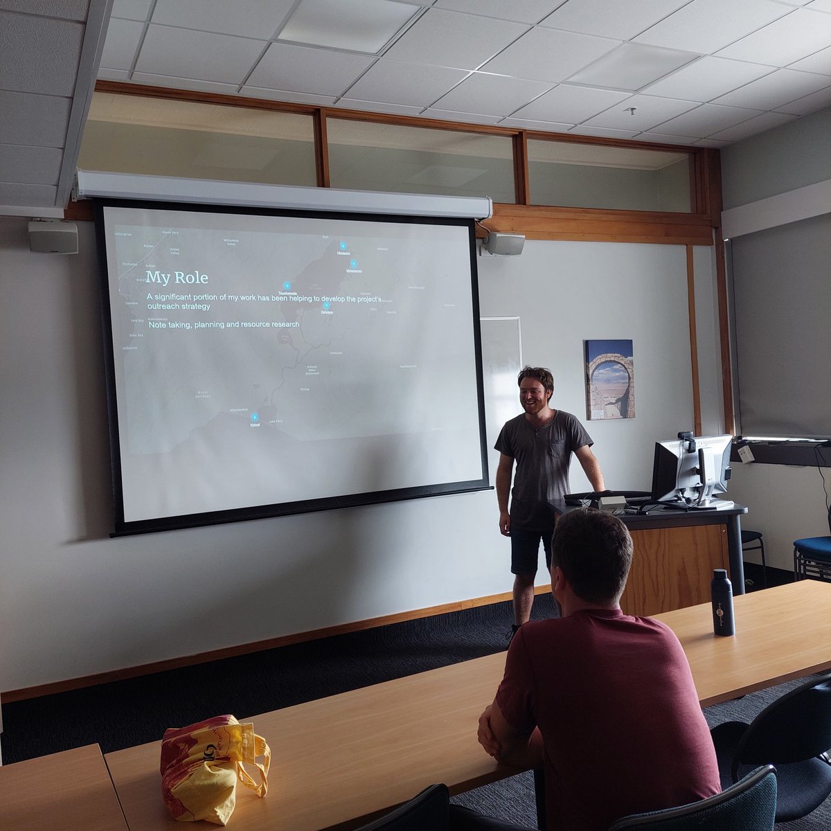
Fraser spoke about the outreach strategy he's been supporting on the #wairarapa project and showed off some of the project's webmaps. #cartography #webmap #outreach #communityEngagement
Webmap of Uyo, Akwa Ibom State, displaying filling stations and two fire stations, with embedded routing for efficient response during fire emergencies—a practical example of disaster management mapping. #GIS #gischat #webmap #disater_management #DataScience #DataAnalytics
Mapmakers of twitter! Post your favorite maps you’ve made, I’ll start
Just built a dashboard using Mapbox GL JS and learned about the new `map.on('idle', () => {...})` listener! I was working on a histogram chart with D3.js to display data based on the map’s viewport. @Mapbox @d3js_org #webmap #spatial #mapping
The OneCity Explorer was developed by @MGIMona Interact with the OneCity Explorer here: arcgis.com/apps/dashboard… #OneCity #WebMap
Launch of OneCity Explorer. Here is the video: youtube.com/watch?v=Xdy_2M… Mapping Access to Services and Quality of Life in Jamaican Cities. @OneCityJA @CapriCaribbean #OneCity #WebMap
We are thrilled to announce that the GeoServer Community has featured a tutorial video from our group on the main page of the GeoServer website! The GeoSpatial Techno group extends their thanks to the GeoServer community for their support. #geoserver #openstandards #webmap #ogc
One of the most popular examples in our Mapbox GL JS Docs is how to create clusters. These unique and dynamic visual markers are a great way to communicate data. See for yourself: buff.ly/3e4xrPu #webdeveloper #webmap #interactivemaps


Our "coalesce" expression lets developers run through a priority list of images and select the first valid option. In this example, learn to use coalesce expressions so that all of your points of interest have a fallback icon: buff.ly/3PDEZvA #webmap #webmapping
Do you want to know how you can ADD NEW FONTS or CHANGE DATA DIRECTORY in geoserver?!🤔 For more information, feel free to watch the tutorial on my YouTube channel here: 👉 youtu.be/F-RlvlwwJgQ 👈 #geoserver #webmap #datadirectory #fonts #webservices


Les GEO URIs : liens hypertexte hyperspatiaux linkedin.com/pulse/les-geo-… via @LinkedIn #embedmap #owlapps #webmap #cartographie #geouri #uri #carte #geodata #geodataviz #kml #earth #google #webmapping #travel #voyage #journey #link

The third part of the GeoServer training focuses on "GeoServer About & Status - A Practical Guide" For more information, feel free to watch the tutorial on my YouTube channel here: 👉youtu.be/F-RlvlwwJgQ👈 #geoserver #webmap #datadirectory #customfont #webservices #opensource

This session covers "Installation Methods of GeoServer on Windows" including the "Windows Installer" and "Web Archive".😍 🌟 For more information, feel free to watch the tutorial from here: 👉 youtu.be/G47vV2od4yc 👈 #geoserver #geospatial #webmap #webservices #openstandards


holy moly. That blog I started writing in November finally has its rough draft done. Now to edit! Hopefully the 360 video maps using EsriJS tutorial will be up tomorrow-ish. #webmap #esrijs #gis #youtubeapi

Afficher des diagrammes (EXTJS) dans une carte interactive linkedin.com/pulse/afficher… via @LinkedIn #webmap #chart #sencha #extjs #ria #diagramme #leafletjs #geomatique #gis #webmapping #geodata #geodataviz #cartographie #embedmap #owlapps


⌛Still time to book your place - @Cadcorp SIS #WebMap Admin #OnlineTraining - mailchi.mp/cadcorp.com/tr… - #GIS #Spatialinsight

Take a minute to explore our #webmap by @AbdulFatawu_ Find more information on our website and GitHub page. Map: tekkigeo.github.io/ejisu_lulc_web…
Something went wrong.
Something went wrong.
United States Trends
- 1. Jamaica 202K posts
- 2. SNAP 975K posts
- 3. New Hope 31.9K posts
- 4. Tucker 88.7K posts
- 5. Nelson 26.8K posts
- 6. Hurricane Melissa 152K posts
- 7. #csm218 3,897 posts
- 8. #NationalFirstRespondersDay 1,069 posts
- 9. Wikipedia 101K posts
- 10. Grokipedia 160K posts
- 11. Nokia 11.8K posts
- 12. $NOK 2,887 posts
- 13. Atlantic 40.4K posts
- 14. Chris Evans 5,908 posts
- 15. Wired 20.7K posts
- 16. jungkook 1.15M posts
- 17. Tylenol 21.1K posts
- 18. Rattler 3,235 posts
- 19. Riley Gaines 96.9K posts
- 20. Jensen 7,783 posts