#spatialdata risultati di ricerca

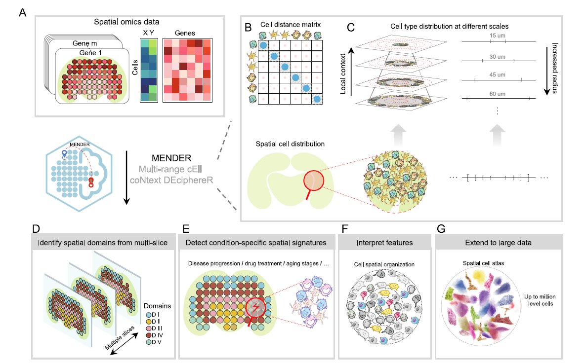
We love learning about new #ComputationalTools for analyzing #SpatialData! MENDER is a novel tissue structure identification tool utilizing cellular neighborhood structures observed across spatial technologies now published in @NatureComms. Learn more: hubs.ly/Q02fCYP20

🌐 Introducing PA statistical methods: Geographic Information Systems (GIS). This integrates spatial data, ideal for exploring environmental influences on physical activity. GIS requires extensive data handling skills. #SpatialData #PhysicalActivityResearch


Awesome week last week representing both @napari_imaging and #SpatialData @scverse at @EuroSciPy2024. It was great to meet maintainers and contributors to the libraries we use. Also grateful for the opportunity to have a flashlight talk on #numpydantic and a little bit on #LinkML


URHIAsti on stage today 11.00 🇪🇪@utuscience @UniTurku #spatialdata #foss4ge @foss4ge @HuDi_Project @BEDLAN_Uralic


Today presenting current status at the #foss4ge2024 Tartu “URHIA's Open Data Journey in Spatial Exploration” 📅Fri, 5.7.2024 at 11.00 📍Omicum building Live stream link available foss4ge.television.ee

Happy to share earlier this month, Avipsa Roy, Asst Prof in Urban Planning & Public Policy was invited as a guest lecturer to discuss Spatial Data Science's influence on policy making at IIT Kharagpur, Visva Bharati University, ISI Kolkata, and IISc Bengaluru. #spatialdata #up3


📍 Looking to expand your business to new locations, but worried about the impact on existing sales? You need Cannibalization Analysis! Maximize profits and safeguard existing revenue with this step-by-step tutorial 👉 hubs.ly/Q02wMFYv0 #analytics #spatialdata

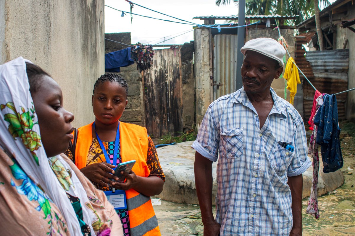
Big up to Wajumbe👏🥳 for aiding mappers on the ground with their invaluable local knowledge & resident trust. They play a crucial role in gathering accurate #spatialdata for the baseline survey & pinpointing initial information, i.e., WCP's locations, dumping sites & waste piles
📍 Looking to expand your business to new locations, but worried about the impact on existing sites? You need Cannibalization Analysis! Maximize profits and safeguard existing revenue with this step-by-step tutorial 👉 hubs.ly/Q02DqVqK0 #analytics #spatialdata


Applied #SpatialData! #BigData #Analytics #DataScience #AI #MachineLearning #IoT #IIoT #GeoSpatial #Python #RStats #TensorFlow #Java #JavaScript #ReactJS #GoLang #CloudComputing #Serverless #DataScientist #Linux #Programming #Coding #100DaysofCode geni.us/Applied-Spatia…
Ready to tackle climate risk? 🌍 See how CARTO helps insurers analyze threats like hurricanes & fires with seamless spatial insights. 📩 Request your demo now: hubs.ly/Q02_3zlc0 #ClimateRisk #SpatialData #CARTO #DataAnalytics

making spatial data easy for pros and non-gis users, catch the full video exclusively on collide.io #gis #spatialdata #dataplatform


What map have you found geoaweseome recently? Spilhaus Ocean Currents map shows how ocean water moves around the world. We love this project! Check it by yourself: arcgis.com/apps/mapviewer… #Geospatial #Geoawesome #SpatialData #cartography #maps #map

A well-designed and comprehensive summary graph about geospatial data tools a couple of times already, circulating on socials by CARTO and their article titled 'What is Spatial Data Science?' lnkd.in/d458sxG6 #datascience #spatialdata #spatialdatascience #gis #python


REGISTRATION OPEN FOR LOKATE MY KASI CHALLENGE Let's congregate on the 7th of December at UNISA for the Lokate My Kasi challenge. What will you build with Mapping Intelligence and Spatial Data? REGISTER HERE: gklink.co/locakemykasi #LokateMyKasi #SpatialData


What is @ApacheSedona and what are its common use cases? Discover how this clustering computing system, designed for processing large-scale spatial data, treats spatial data as a first-class citizen. bit.ly/3ZRL24U #ApacheSeonda #SpatialData


Looking forward to working with @confeycollege TY students on their projects on Kippure and the river Liffey. We'll be using #spatialdata in #arcgisonline and using #storymapping to display their work. Get in touch to get your TY students invoved #believeinscience
🚀JoRAS英語版ポスター初公開!🌎研究者の皆さま、共同研究に参加しませんか?#JoRAS は@CSISutが運用する共同研究利用システムです。1,000件以上の空間データで毎年200+の共同研究を支援中! 👉csis.u-tokyo.ac.jp/news/joras_eng… 🔗SNS linktr.ee/CSISut #CSIS_UTokyo #SpatialData


In case you missed our course launch or want to refer back to something that was discussed, you can find the link here 👉🏽 youtu.be/z6zEg6Es2lo #Training #spatialdata #arcgis #remotesensing #storymap

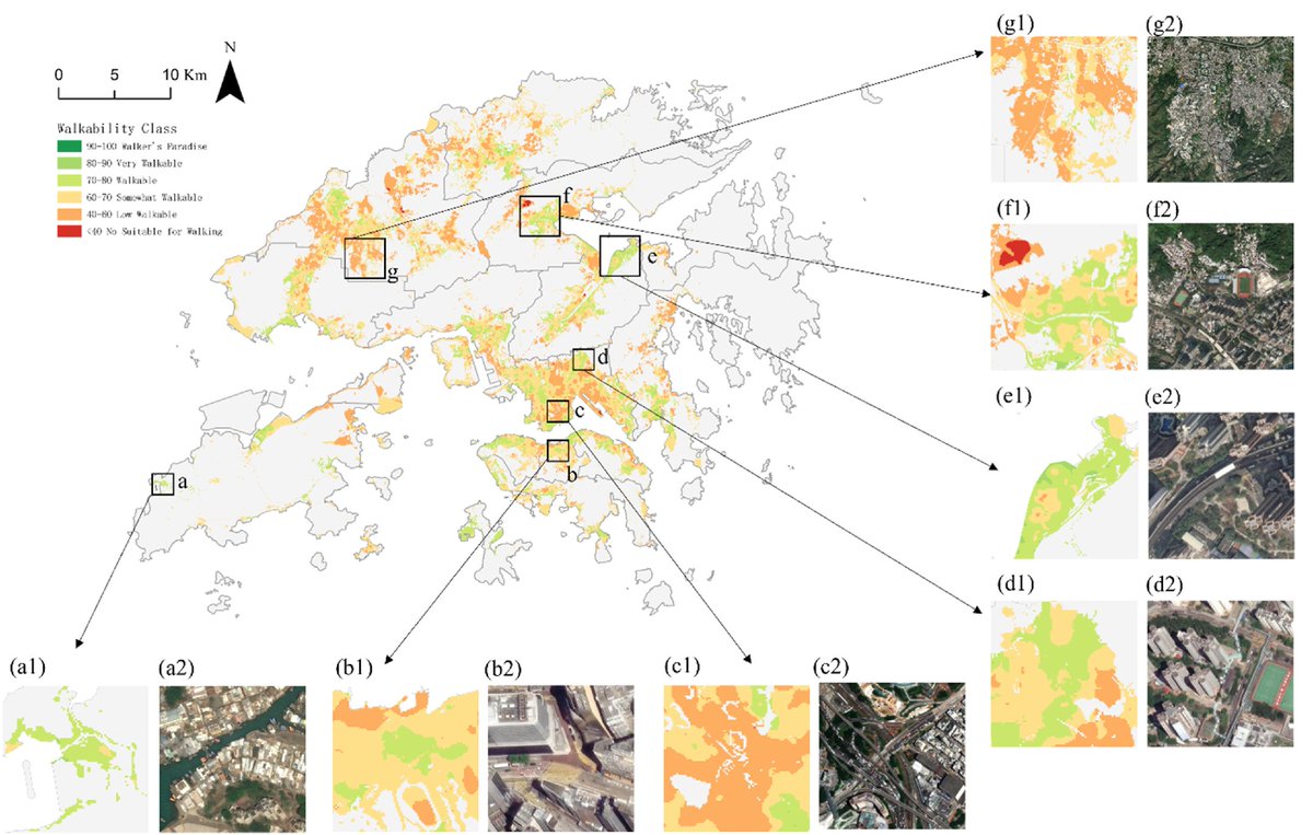
🚶 Is Hong Kong walkable considering convenience, safety and comfort? 🎯 Results from 400,000+ walkways exposes deep inequalities of walkability between urban and rural areas, based on multi-source data. doi.org/10.1016/j.infg… #PedestrianNetwork #SpatialData #UrbanPlanning

In short: ➡️ Detection shows where clustering happens. ➡️ Interpretation reveals why it matters. #SpatialData #SpatialClustering #GIS #SpatialAnalysis #HotspotAnalysis #LISA #MoranI #GeospatialAnalysis #DataScience #SDSSN

📍 Geospatial data relates information to specific locations, revealing patterns and insights that help us plan, protect, and improve our world. 🌍 #SpatialData #GeoInsights


At JapakGIS, we assist Public health agencies use Web Maps dashboards to track epidemic spread, visualize hotspots, and allocate medical resources effectively. #JapakGIS #SpatialData #SpatialAnalytics #GISForDevelopment #GeospatialSolutions

the data tells truly reflects the real world. #SpatialData #SpatialDependence #SpatialLag #SpatialErrorModel #SpatialAnalysis
neighborhoods with low service access. * Environmental scientists use it to identify pollution concentration zones. 💡 In short, LISA helps transform maps into insights one local pattern at a time. #SpatialData #LISA #SpatialAutocorrelation #DataScience #GeospatialAnalysis #GIS
💡 Why it matters: Hotspot analysis helps researchers, urban planners, and decision-makers pinpoint priority areas, allocate resources effectively, and design targeted interventions. #SpatialData #GIS #GeospatialAnalysis #DataScience #HotspotAnalysis
💡 Don’t miss it, it’s happening this evening at 6 PM (WAT)! #SDSSN #GeospatialDataScience #SpatialData #GIS #DataScience
💡 Don’t miss it, it’s happening tomorrow evening at 6 PM (WAT)! #SDSSN #GeospatialDataScience #SpatialData #GIS #DataScience

Proud to support the expansion of Land iQ with MetroMap aerial imagery. $20M investment → greater access, new tools, smarter land planning. nsw.gov.au/ministerial-re… #LandIQ #MetroMap #SpatialData


We love learning about new #ComputationalTools for analyzing #SpatialData! MENDER is a novel tissue structure identification tool utilizing cellular neighborhood structures observed across spatial technologies now published in @NatureComms. Learn more: hubs.ly/Q02fCYP20

More oblique views. Now I'll have to find out how to bring point data to Blender so I can overlay precise locations. I've managed to bring in shapefile but haven't been able to convert that into object. #gis #blender #spatialdata


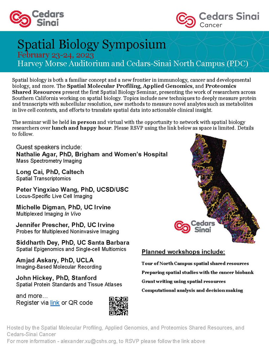
#CedarsSinaiCancer's first #SpatialBiology Symposium is taking place covering topics like new techniques to measure proteins, methods to measure novel analytes, and efforts to translate #spatialdata into clinical insights. Virtual attendees are welcome!
URHIAsti on stage today 11.00 🇪🇪@utuscience @UniTurku #spatialdata #foss4ge @foss4ge @HuDi_Project @BEDLAN_Uralic
Today presenting current status at the #foss4ge2024 Tartu “URHIA's Open Data Journey in Spatial Exploration” 📅Fri, 5.7.2024 at 11.00 📍Omicum building Live stream link available foss4ge.television.ee

#showcasing #students Jevaughn #spatialdata #analyst #Jamaica jevaughnhenry.wixsite.com/my-site/projec… #ePortfolio #PLUS #creative #drone #projects #Check his #CV & impressive #skills list 😎 #data #visualisation #UAV #Copernicus #DigitalEarth #EO #GI #Geocommunication #UPOL #Geospatial #MSc
My latest article, 𝐄𝐱𝐩𝐥𝐨𝐫𝐢𝐧𝐠 𝐋𝐚𝐫𝐠𝐞-𝐬𝐜𝐚𝐥𝐞 𝐑𝐚𝐬𝐭𝐞𝐫 𝐏𝐨𝐩𝐮𝐥𝐚𝐭𝐢𝐨𝐧 𝐃𝐚𝐭𝐚, is out on @TDataScience: towardsdatascience.com/exploring-larg… #geosptaialdata #geodata #spatialdata #datavisualization #datascience #data #datafam #visualization #gis #geography


Welcome to the 6th day of 12 Days of NanoString! Interested in leaping to single-cell spatial in these applications? nanostring.com/events/spatial… #SpatialData #CellSegmentation #SpatialTranscriptomics #SingleCellImaging

My recent article, 𝐄𝐱𝐩𝐥𝐨𝐫𝐢𝐧𝐠 𝐋𝐚𝐫𝐠𝐞-𝐬𝐜𝐚𝐥𝐞 𝐑𝐚𝐬𝐭𝐞𝐫 𝐏𝐨𝐩𝐮𝐥𝐚𝐭𝐢𝐨𝐧 𝐃𝐚𝐭𝐚, published on @TDataScience: towardsdatascience.com/exploring-larg… @WorldPopProject #geosptaialdata #geodata #spatialdata #gis #geography #datascience #datavisualizatiom #ai


🌐 Introducing PA statistical methods: Geographic Information Systems (GIS). This integrates spatial data, ideal for exploring environmental influences on physical activity. GIS requires extensive data handling skills. #SpatialData #PhysicalActivityResearch

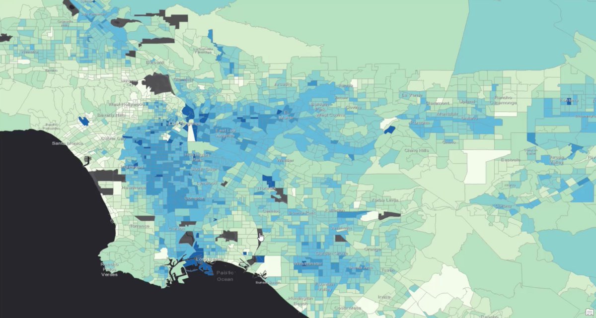
See how #ArcGISKnowledge helped healthcare agencies better understand patient accessibility. Visualizing their data through graph analytics showed which areas lacked insurance-covered patient care. Read the blog: esri.social/9p6c50PBHzK #SpatialData #GIS #ArcGIS

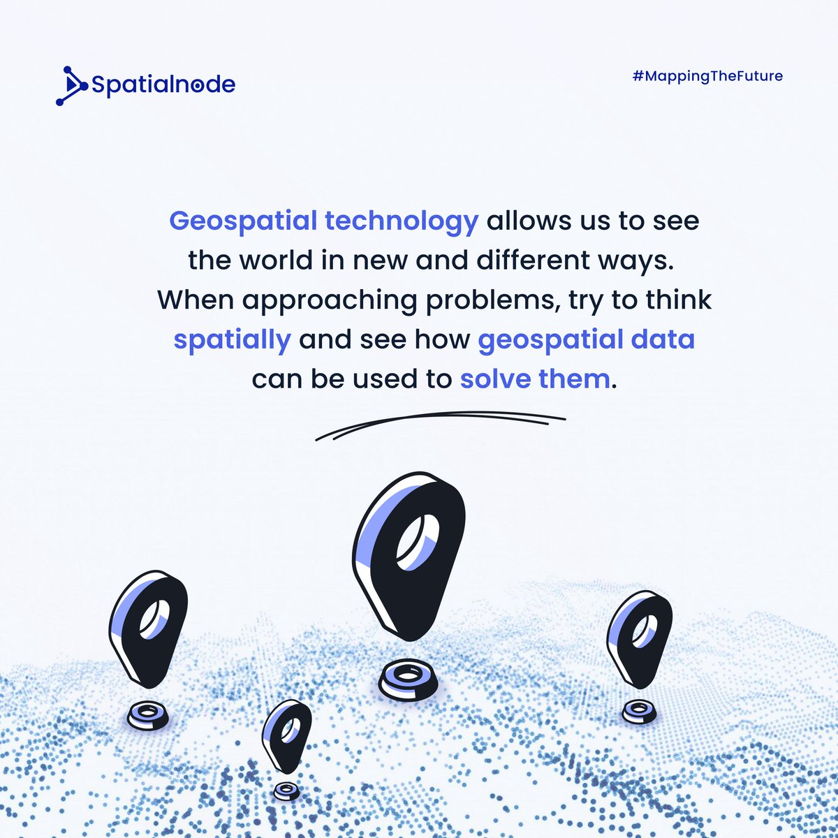
Spatialnode Monday Tips It's a new week! Let's think spatially this week! #geospatial #mondaymotivation #spatialdata
As the #30daymapchallenge is almost here, it is timely to recap on geospatial data viz tools for Python: ow.ly/KjBi50Q2w27 #gis #datascience #maps #geospatialdata #datavisualization #spatialanalytics #spatialdata#geospatial #data #ai


A round of applause to all the contributors of the Map El Niño Mapathon Campaign 👏✨️👏. Each week is an advancement in the number of contributions being made. Well done everyone. And by the way we're live for this week's Mapathon 😀 #elninathon #spatialdata


Dr. Urooj Saeed Senior Specialist GIS, presented GIS data sets, layers and analysis. The interactive session with CERP team included discussion on GIS & RS data, attributed data, spatial patterns & spatial data repository and big data repository. #DataAnalytics #spatialdata

Applied #SpatialData! #BigData #Analytics #DataScience #AI #MachineLearning #IoT #IIoT #GeoSpatial #Python #RStats #TensorFlow #Java #JavaScript #ReactJS #GoLang #CloudComputing #Serverless #DataScientist #Linux #Programming #Coding #100DaysofCode geni.us/Applied-Spatia…
Awesome week last week representing both @napari_imaging and #SpatialData @scverse at @EuroSciPy2024. It was great to meet maintainers and contributors to the libraries we use. Also grateful for the opportunity to have a flashlight talk on #numpydantic and a little bit on #LinkML

🌐 Introducing PA statistical methods: Geographic Information Systems (GIS). This integrates spatial data, ideal for exploring environmental influences on physical activity. GIS requires extensive data handling skills. #SpatialData #PhysicalActivityResearch


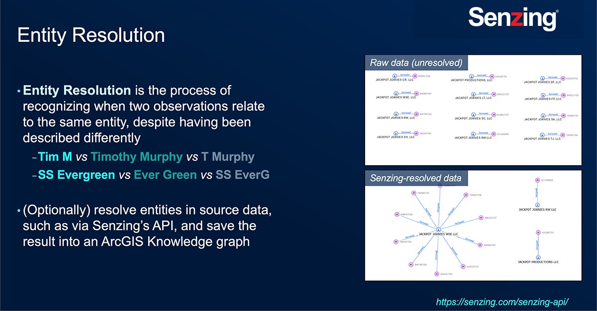
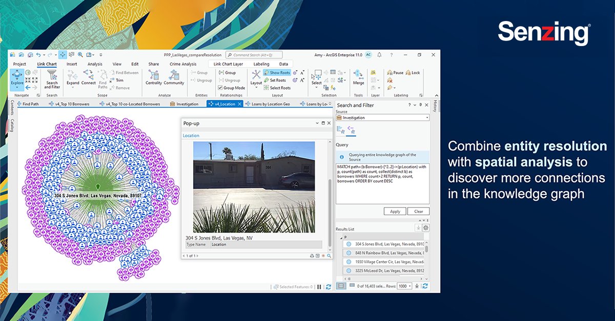
Last week my team and I attended #EsriFedGIS2023. @Senzing and @Esri have partnered to merge #NonSpatial third-party data together with #SpatialData using #ArcGIS Knowledge and perform link analysis using #ArcGISpro. #ArcGISKnowledge #SenzingPartner #ESRIPartner
Something went wrong.
Something went wrong.
United States Trends
- 1. Cheney 48.3K posts
- 2. First Take 42.8K posts
- 3. #ExpediaChat N/A
- 4. Nano Banana Pro 16.3K posts
- 5. Cam Newton 2,543 posts
- 6. Sedition 93K posts
- 7. Stephen A 37.7K posts
- 8. #AcousticPianoSnowGlobe 2,044 posts
- 9. Treason 58.6K posts
- 10. Trump and Vance 29.8K posts
- 11. #LoveDesignFinalEP 366K posts
- 12. SEDITIOUS BEHAVIOR 15.5K posts
- 13. FINAL DRAFT FINAL LOVE 401K posts
- 14. Bush 53.7K posts
- 15. #XboxPartnerPreview 2,273 posts
- 16. Eddie Hennessy N/A
- 17. Husqvarna 1,209 posts
- 18. Godzilla 20.9K posts
- 19. #WeekndTourLeaks 1,215 posts
- 20. Stuart Scott 2,416 posts