#spatialdata 搜尋結果

Geospatial data reveals the power of where helping us build smarter roads, manage energy better, and protect our planet. With real-time insights, we make faster, smarter decisions for resilient, sustainable cities. #GeoTech #SmartInfrastructure #EarthData #TechForGood


Smarter decisions about real-world problems start with better data – and #EarthObservation can provide just that, thanks to European efforts to open up access to massive amounts of satellite data collected every day. bit.ly/48rnO8m


Expanding the Data Stream with #GIS;#GIS is an essential component in many decision and management processes. A well-structured #GIS provides invaluable tools to visualize, analyze and query #geospatial data 7wdata.be/data-analysis/…


😲 Existing variograms neglect the geographic environment's impact on variable variation! A new variogram analysis method is here 🌟. It uses both geographic and feature space to reveal spatial distribution patterns of soil property. This breakthrough can differentiate patterns…


Professionals Arabia Co. | Real-Time GIS Surveying Accelerate decisions with high-precision GIS data for infrastructure and environmental projects. GNSS RTK/PPK, UAV mapping, mobile GIS, cloud sync, and regulatory-compliant QA/QC. #GIS #ArcGIS #SpatialData


When #VPS locks onto a high-fidelity, machine-readable #3D map, the whole #SpatialIntelligence loop becomes reliable end-to-end. Great demo from @BilawalSidhu and @multiset_ai using #XGRIDS data. #3DMapping #SpatialComputing

Strong geospatial AI starts with a maturity check. 💪 AI-driven spatial insights only work when the underlying data is reliable and governed. Benchmark your organization’s readiness with a Spatial Governance Maturity Model: hubs.ly/Q03WQ6B70


#30DayMapChallenge Day 29: Raster🎨 Today is a “paint by numbers” raster grid of soil moisture based on NASA’s SMAP. Shout out if you’d like a copy to “paint” yourself. Soil moisture is a key piece of the flood puzzle: when soils are already saturated, floods can escalate fast.

MySQLアドカレ2日目! MySQLのSpatial Index, Geohash, 座標値による空間検索の性能評価(あるいはSRID 4326のSpatial Indexが遅い件について) - shunyas’s diary shunyas.hatenablog.com/entry/2025/12/…


Context. Clarity. A living map that understands itself. That’s when decisions become smarter, ecosystems grow faster, and onchain truly meets the real world. @integra_layer #Integra #IRL #SpatialData

Unlock the full potential of your spatial data with Professionals Arabia Co. ✔️ SDE setup (SQL Server, Oracle, PostGIS) ✔️ Multi-user editing & versioning ✔️ Data migration & performance tuning ✔️ Secure access, ArcGIS integration #GIS #ArcGIS #SpatialData


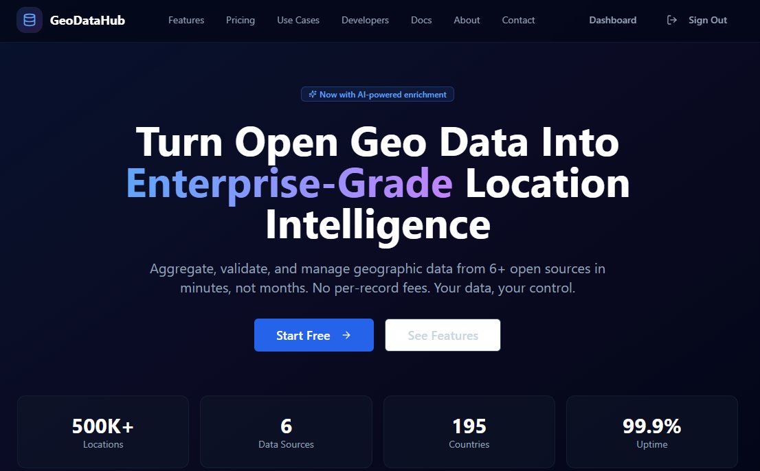
📢 Enterprise Geo-Data Redefined [GeoDataHub.app] 🚀 Businesses worldwide struggle with complex, outdated, and insecure geographic data. GeoDataHub is changing that. We provide a secure, scalable, and intelligent platform for all your location intelligence needs, built…
![VasilisPasparas's tweet image. 📢 Enterprise Geo-Data Redefined [GeoDataHub.app] 🚀
Businesses worldwide struggle with complex, outdated, and insecure geographic data. GeoDataHub is changing that. We provide a secure, scalable, and intelligent platform for all your location intelligence needs, built…](https://pbs.twimg.com/media/G7P8UmpWsAErEZ-.jpg)
![VasilisPasparas's tweet image. 📢 Enterprise Geo-Data Redefined [GeoDataHub.app] 🚀
Businesses worldwide struggle with complex, outdated, and insecure geographic data. GeoDataHub is changing that. We provide a secure, scalable, and intelligent platform for all your location intelligence needs, built…](https://pbs.twimg.com/media/G7P8Z10WYAA8C8K.jpg)
![VasilisPasparas's tweet image. 📢 Enterprise Geo-Data Redefined [GeoDataHub.app] 🚀
Businesses worldwide struggle with complex, outdated, and insecure geographic data. GeoDataHub is changing that. We provide a secure, scalable, and intelligent platform for all your location intelligence needs, built…](https://pbs.twimg.com/media/G7P8fOvWwAA0OzJ.jpg)
![VasilisPasparas's tweet image. 📢 Enterprise Geo-Data Redefined [GeoDataHub.app] 🚀
Businesses worldwide struggle with complex, outdated, and insecure geographic data. GeoDataHub is changing that. We provide a secure, scalable, and intelligent platform for all your location intelligence needs, built…](https://pbs.twimg.com/media/G7P8qxNXEAA8GLs.jpg)
📢 Enterprise Geo-Data Redefined: Welcome to GeoDataHub.app! 🚀 Businesses worldwide struggle with complex, outdated, and insecure geographic data. GeoDataHub is changing that. We provide a secure, scalable, and intelligent platform for all your location intelligence…

ISSデジタルツインと地球デジタルツインのシームレスな連結を実現 spacedata.jp/news/202511_te… #spacedata #Tech #AI #衛星データ

実際のISS軌道データ、地球観測情報、Omniverse/USD基盤、Unreal Engineの高精度レンダリングを統合することで、宇宙環境と地球環境をリアルに再現しています。🌏 教育・研究、防災、都市開発、メディアなど幅広い分野での活用が期待され、今後は月・火星など他天体にも拡張していきます。 #SpaceData
【🌏技術開発アップデート🪐】 スペースデータは、ISSデジタルツインと地球デジタルツインをシームレスに連結し、宇宙と地球を行き来できる新しい3Dプラットフォームの第一歩として、ISSと地球との地理空間情報を連携させました #SpaceData #デジタルツイン
Every ecosystem has data. But only @integra_layer gives it a heartbeat. When movement becomes memory, and land becomes language, cities stop being structures they become stories. And suddenly, the world isn’t just mapped… it’s understood. #Integra #SpatialData #IRL


Andrew Farmer, DPhil, CSO and Head of R&D, explores how current limitations in cost, complexity, and resolution are holding back the wider adoption of spatial—and why innovation is critical for the future of life sciences. Explore the new era of #spatial: ow.ly/4F2950XtFVC


Data prep shouldn't take longer than the actual analysis. @nextgis geodata: pre-validated, pre-styled, ready to use. Basemaps, buildings, elevation, satellite imagery, landcover, POIs. 50% off Dec 1-5 | Works in any GIS tool linkly.link/2Rlit⚡ #Geodata #GIS #SpatialData

Something went wrong.
Something went wrong.
United States Trends
- 1. Bama 51.1K posts
- 2. Georgia 62.1K posts
- 3. #NXTDeadline 15K posts
- 4. Ty Simpson 7,481 posts
- 5. Miami 229K posts
- 6. #UFC323 25.1K posts
- 7. #GoDawgs 15.1K posts
- 8. #SECChampionship 5,441 posts
- 9. Ryan Williams 2,827 posts
- 10. DeBoer 4,511 posts
- 11. Frank Martin 2,466 posts
- 12. Kirby 15.4K posts
- 13. Kendal Grey 1,047 posts
- 14. Vettori 1,844 posts
- 15. Texas Tech 32.5K posts
- 16. Jalin Turner 1,523 posts
- 17. Grubb 2,437 posts
- 18. Oba Femi 7,825 posts
- 19. #RollTide 3,093 posts
- 20. Gus Johnson N/A