#spatialdata résultats de recherche

Introducing SpatialVID: A massive new video dataset for 3D spatial intelligence Crucial for training next-gen models, it features over 7,000 hours of diverse, in-the-wild video with dense annotations like camera poses, depth maps, and dynamic masks.


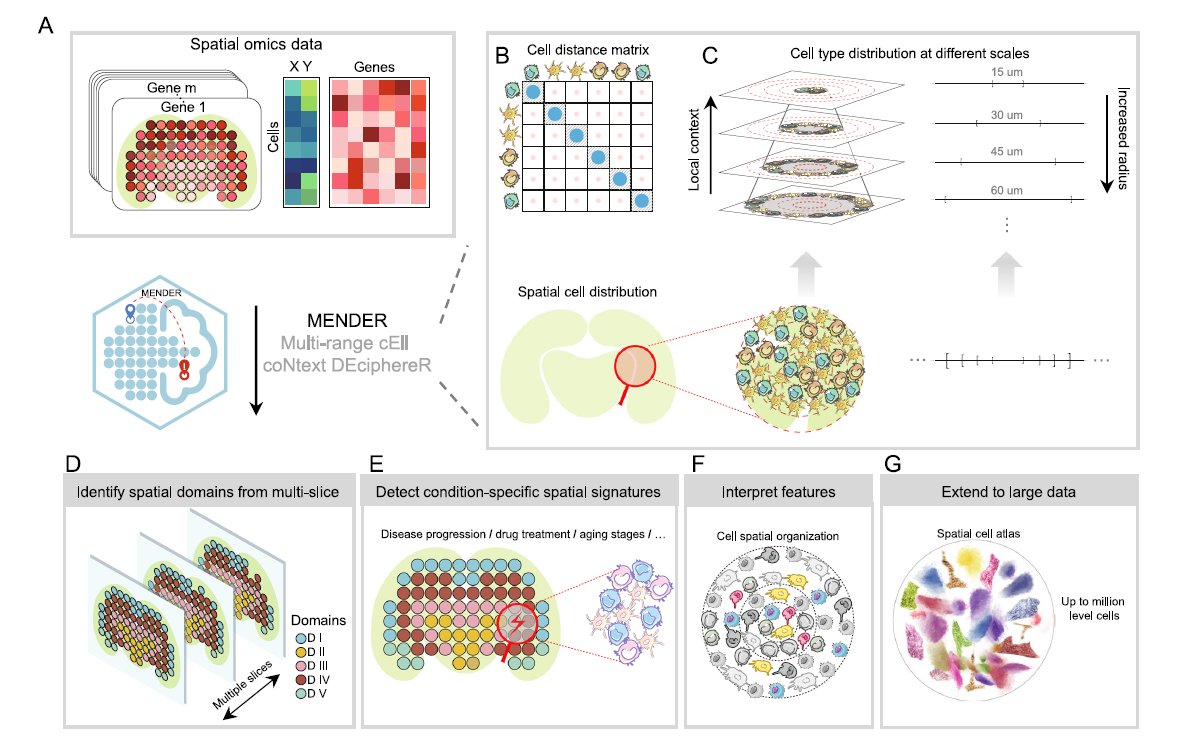
We love learning about new #ComputationalTools for analyzing #SpatialData! MENDER is a novel tissue structure identification tool utilizing cellular neighborhood structures observed across spatial technologies now published in @NatureComms. Learn more: hubs.ly/Q02fCYP20

The spatial computing stack, simplified: Our visual tools let you manipulate everything We handle the complexity. You focus on creation

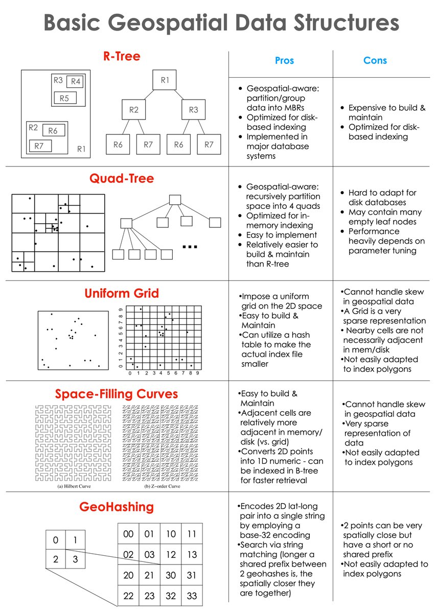
Prepped a cheat sheet for the basic geospatial data structures and the pros/cons of each. Most existing geospatial indexes / data partitioning methods stem from or build upon them. Hope you find it useful 👇🏽 #geospatial #DataAnalytics #Database #Indexes

Introducing SnorkelSpatial: A New Benchmark for Evaluating Spatial Reasoning in LLMs Spatial reasoning is everywhere from navigating city maps to understanding molecular interactions. But how well do LLMs handle tasks that require tracking objects moving through space?

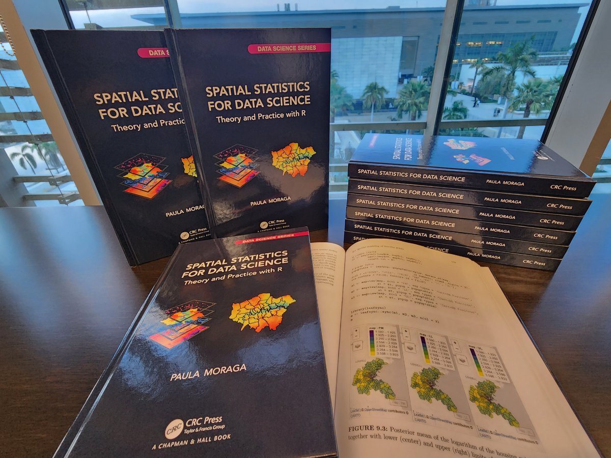
📢 Delighted to share the cover of my book Spatial Statistics for Data Science: Theory and Practice with R 😍😍😍 🔗 paulamoraga.com/book-spatial/ Thanks so much to my editor @lara_crc & all the team at @CRC_MathStats! The book will be available soon! #rstats #stats #datascience


🚨New #SpatialTranscriptomics #Bioinformatics data resource out in @naturemethods. SODB, a platform with >2,400 manually curated spatial experiments from >25 spatial omics technologies & interactive analytical modules. This🧵will walk you through all the features of SODB [1/33]
![simocristea's tweet image. 🚨New #SpatialTranscriptomics #Bioinformatics data resource out in @naturemethods.
SODB, a platform with >2,400 manually curated spatial experiments from >25 spatial omics technologies & interactive analytical modules.
This🧵will walk you through all the features of SODB [1/33]](https://pbs.twimg.com/media/FpqfK6HaUAAQZAo.jpg)

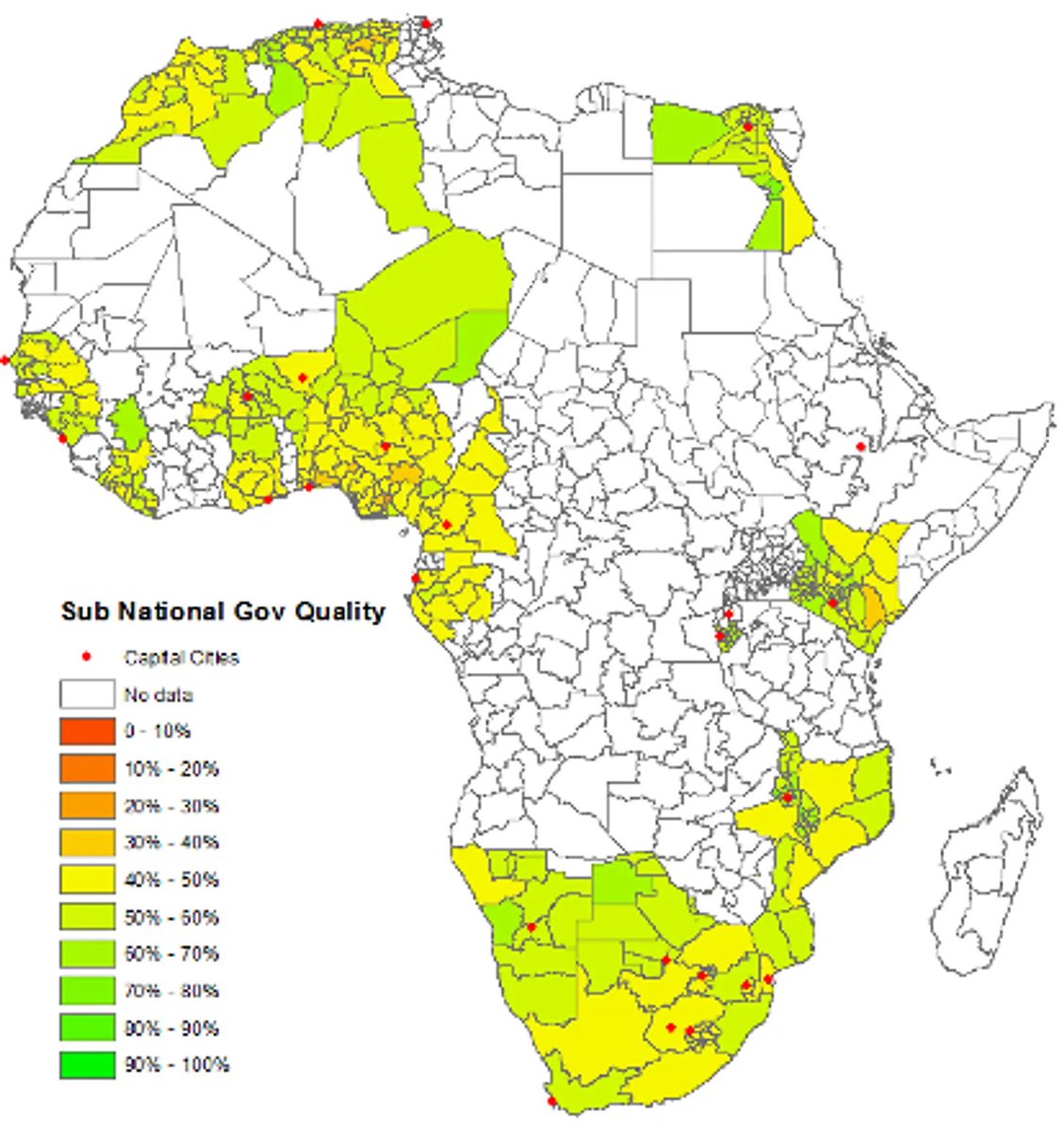
Traditional data fails to capture corruption of local governments. Why? It's due to data paucity. Here's how geospatial data is changing this:
Everything you need to know about spatial autocorrelation. PLUS: how to access free high-res satellite data, how super-resolution uses game theory, how to properly use Google Trends data, and more. Here's everything I wrote about last week:


Accurate storm surge predictions are critical for giving coastal residents time to evacuate and giving emergency responders time to prepare. space.com/science/climat…


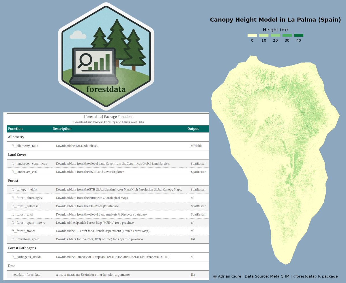
Working with environmental data often means searching through multiple sources and handling messy file formats. The forestdata R package solves this by bringing global forest, land-use, and canopy height datasets directly into R. It makes exploring large-scale ecological data…

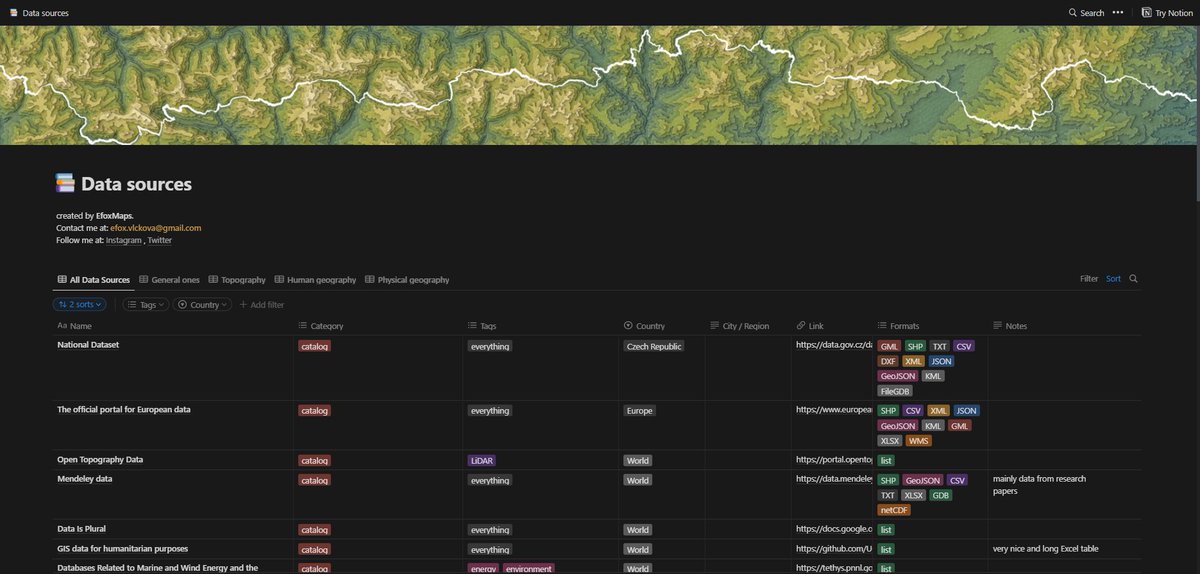
Data. I finally compiled the list of about 200 data resoures. Have fun 😊 tinyurl.com/spatialdataa #gischat
I just received the hardcopies of my book ✨ Spatial Statistics for Data Science ✨ 👉 paulamoraga.com/book-spatial/ Many thanks @CRC_MathStats! They look great! 🤩 💻#rstats 🗺️#rspatial ⚡️#gischat 📊#RINLA 📈#datascience 🌍#dataviz 🌈#epitwitter 🌿#ecology 📕 #statistics

Meet Felt’s native H3 support. Just like all things we build, it really flies. Here are 3 reasons H3 in Felt is so unique ⤵️ #GIS #Mapping #SpatialData

Awesome week last week representing both @napari_imaging and #SpatialData @scverse at @EuroSciPy2024. It was great to meet maintainers and contributors to the libraries we use. Also grateful for the opportunity to have a flashlight talk on #numpydantic and a little bit on #LinkML


The Spatial Web: Bridging Digital and Physical Worlds Through Smart Standards The Spatial Web: Bridging Digital and Physical Worlds Through Smart Standards schematical.com/posts/spatial-…

I spent some time this weekend trying to get spatial results into sp_QuickieStore to help show the magnitude of query performance issues. It sort of works, but I’m not thrilled with it. There’s no way to label the X/Y axis or have a default label for the shapes.


2 WEEKS AWAY! 🥳 Prevent yourself from future FOMO & sign up for Esri's popular course today: esri.social/xJq350SWk38 #SpatialDataScience #ArcGIS #SpatialData


GPS doesn’t work indoors — but AI still needs to see where people move. Meet Crowd Connected, the UK Fast Growth Index company mapping real-world movement in real time. movetheneedle.news/technology/map… #AI #SpatialData #DigitalTransformation #IndoorPositioning


The Lands Department announces the extension of the #3DIndoorMap and #3DIndoorNetwork to all Mass Transit Railway stations, providing comprehensive #SpatialData for the benefit of travellers news.gov.hk/eng/2025/10/20…

Join Dr Niamh Mimnagh, 17–21 Nov Introduction to Spatial Data Analysis Learn to import, explore, model, and visualise spatial data using real research examples! Register: tinyurl.com/prstats-isda01 #PhDLife #RStats #SpatialData #DataScience #GIS #Mapping #AcademicChatter

🚀JoRAS英語版ポスター初公開!🌎研究者の皆さま、共同研究に参加しませんか?#JoRAS は@CSISutが運用する共同研究利用システムです。1,000件以上の空間データで毎年200+の共同研究を支援中! 👉csis.u-tokyo.ac.jp/news/joras_eng… 🔗SNS linktr.ee/CSISut #CSIS_UTokyo #SpatialData

🚀Now live: English poster of #JoRAS, the Joint-Use Spatial Data Platform for Researchers Worldwide by @CSISut with 1K+ Japan-focused dataset, supporting 200+ projects/year. Join us today! 👉csis.u-tokyo.ac.jp/news/joras_eng… 🔗Follow us linktr.ee/CSISut #CSIS_UTokyo #SpatialData
Want to turn spatial data into clear, publication-ready maps? Join Dr Martijn Tennekes, 10–14 Nov Learn to create static & interactive maps in R with tmap Register: tinyurl.com/prstats-tmap02 #PhDLife #RStats #SpatialData #Mapping #DataVisualisation #GIS #OpenScience #Geospatial

🌆 Urban planning & policy 📊 Embracing spatial heterogeneity ensures more accurate models, better insights, and smarter decisions in GIS! 👉 Visit: sdssn.org #SDSSN #DataScience #SpatialData #GIS #Nigeria
📌 Take the step today your recognition starts here. 👉 Visit: sdssn.org #SDSSN #DataScience #SpatialData #GIS #Nigeria
🔹 Hands-on Tools: R (gstat), Python (GSTools), and ArcGIS for practical implementation. It is all about detecting structure in spatial data and building the foundation for advanced geostatistical predictions. #SpatialData #Geostatistics #DataScience #Variogram #ArcGIS #Python


We love learning about new #ComputationalTools for analyzing #SpatialData! MENDER is a novel tissue structure identification tool utilizing cellular neighborhood structures observed across spatial technologies now published in @NatureComms. Learn more: hubs.ly/Q02fCYP20

More oblique views. Now I'll have to find out how to bring point data to Blender so I can overlay precise locations. I've managed to bring in shapefile but haven't been able to convert that into object. #gis #blender #spatialdata


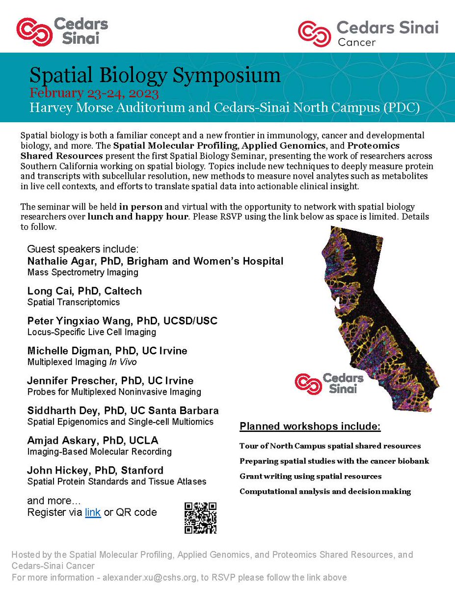
#CedarsSinaiCancer's first #SpatialBiology Symposium is taking place covering topics like new techniques to measure proteins, methods to measure novel analytes, and efforts to translate #spatialdata into clinical insights. Virtual attendees are welcome!

#showcasing #students Jevaughn #spatialdata #analyst #Jamaica jevaughnhenry.wixsite.com/my-site/projec… #ePortfolio #PLUS #creative #drone #projects #Check his #CV & impressive #skills list 😎 #data #visualisation #UAV #Copernicus #DigitalEarth #EO #GI #Geocommunication #UPOL #Geospatial #MSc

URHIAsti on stage today 11.00 🇪🇪@utuscience @UniTurku #spatialdata #foss4ge @foss4ge @HuDi_Project @BEDLAN_Uralic


Today presenting current status at the #foss4ge2024 Tartu “URHIA's Open Data Journey in Spatial Exploration” 📅Fri, 5.7.2024 at 11.00 📍Omicum building Live stream link available foss4ge.television.ee

My latest article, 𝐄𝐱𝐩𝐥𝐨𝐫𝐢𝐧𝐠 𝐋𝐚𝐫𝐠𝐞-𝐬𝐜𝐚𝐥𝐞 𝐑𝐚𝐬𝐭𝐞𝐫 𝐏𝐨𝐩𝐮𝐥𝐚𝐭𝐢𝐨𝐧 𝐃𝐚𝐭𝐚, is out on @TDataScience: towardsdatascience.com/exploring-larg… #geosptaialdata #geodata #spatialdata #datavisualization #datascience #data #datafam #visualization #gis #geography


Welcome to the 6th day of 12 Days of NanoString! Interested in leaping to single-cell spatial in these applications? nanostring.com/events/spatial… #SpatialData #CellSegmentation #SpatialTranscriptomics #SingleCellImaging


Spatialnode Monday Tips It's a new week! Let's think spatially this week! #geospatial #mondaymotivation #spatialdata

Dr. Urooj Saeed Senior Specialist GIS, presented GIS data sets, layers and analysis. The interactive session with CERP team included discussion on GIS & RS data, attributed data, spatial patterns & spatial data repository and big data repository. #DataAnalytics #spatialdata


🌐 Introducing PA statistical methods: Geographic Information Systems (GIS). This integrates spatial data, ideal for exploring environmental influences on physical activity. GIS requires extensive data handling skills. #SpatialData #PhysicalActivityResearch


A round of applause to all the contributors of the Map El Niño Mapathon Campaign 👏✨️👏. Each week is an advancement in the number of contributions being made. Well done everyone. And by the way we're live for this week's Mapathon 😀 #elninathon #spatialdata


🌐 Introducing PA statistical methods: Geographic Information Systems (GIS). This integrates spatial data, ideal for exploring environmental influences on physical activity. GIS requires extensive data handling skills. #SpatialData #PhysicalActivityResearch


Happy to share earlier this month, Avipsa Roy, Asst Prof in Urban Planning & Public Policy was invited as a guest lecturer to discuss Spatial Data Science's influence on policy making at IIT Kharagpur, Visva Bharati University, ISI Kolkata, and IISc Bengaluru. #spatialdata #up3

My recent article, 𝐄𝐱𝐩𝐥𝐨𝐫𝐢𝐧𝐠 𝐋𝐚𝐫𝐠𝐞-𝐬𝐜𝐚𝐥𝐞 𝐑𝐚𝐬𝐭𝐞𝐫 𝐏𝐨𝐩𝐮𝐥𝐚𝐭𝐢𝐨𝐧 𝐃𝐚𝐭𝐚, published on @TDataScience: towardsdatascience.com/exploring-larg… @WorldPopProject #geosptaialdata #geodata #spatialdata #gis #geography #datascience #datavisualizatiom #ai


Applied #SpatialData! #BigData #Analytics #DataScience #AI #MachineLearning #IoT #IIoT #GeoSpatial #Python #RStats #TensorFlow #Java #JavaScript #ReactJS #GoLang #CloudComputing #Serverless #DataScientist #Linux #Programming #Coding #100DaysofCode geni.us/Applied-Spatia…

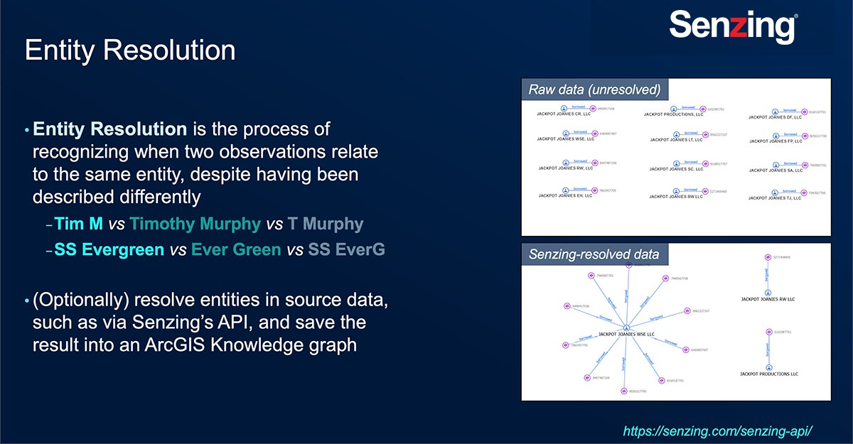
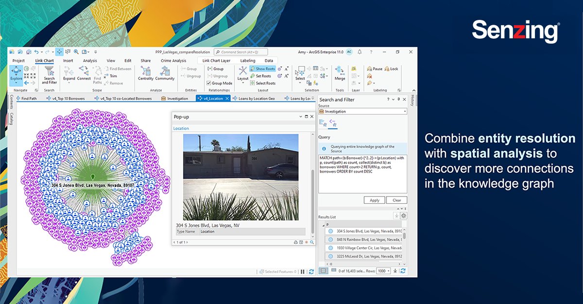
Last week my team and I attended #EsriFedGIS2023. @Senzing and @Esri have partnered to merge #NonSpatial third-party data together with #SpatialData using #ArcGIS Knowledge and perform link analysis using #ArcGISpro. #ArcGISKnowledge #SenzingPartner #ESRIPartner
Awesome week last week representing both @napari_imaging and #SpatialData @scverse at @EuroSciPy2024. It was great to meet maintainers and contributors to the libraries we use. Also grateful for the opportunity to have a flashlight talk on #numpydantic and a little bit on #LinkML
🚀 Struggling to map your @PostgreSQL / @postgis data? Check out our latest tutorial! 🎓 In under a minute, learn how to seamlessly integrate your spatial data with Felt. 🗺️ youtu.be/77UK-lbBsYw #GIS #SpatialData #DataVisualization #postgresql #postgis


Something went wrong.
Something went wrong.
United States Trends
- 1. #WorldSeries 198K posts
- 2. Dodgers 242K posts
- 3. Freddie 90.7K posts
- 4. Klein 197K posts
- 5. Ohtani 131K posts
- 6. Kershaw 19.2K posts
- 7. Mookie 15.1K posts
- 8. Yamamoto 27.3K posts
- 9. #Worlds2025 8,150 posts
- 10. Lauer 5,149 posts
- 11. Joe Davis 2,247 posts
- 12. Will Smith 13.9K posts
- 13. WHAT A GAME 41.9K posts
- 14. Marlins 1,873 posts
- 15. 18 INNINGS 13.4K posts
- 16. Dave Roberts 6,112 posts
- 17. Bottom of the 18th 2,378 posts
- 18. Schneider 12.7K posts
- 19. Tommy Edman 4,948 posts
- 20. Mary Hart N/A